Showing posts with label hong kong. Show all posts

Monday, November 30, 2020

Thousand Islands - Tai Lam Chung Reservoir (大欖涌水塘) - The easy (and crowded) way

Duration:  7.5 km (2:15h)

Difficulty: 4/10. 212m elevation gain.

Cel phone coverage: Everywhere

Water needs: 1 liter. 90% shaded. 

Appreciation: 6/10. The more difficult way to get the Thousand Islands view is also prettier: http://www.hongkonghikes.com/2016/02/thousand-islands-tai-lam-chung-reservoir.html 

Exercise Area: No

Transportation:  Get to Tuen Mun MTR station. Take green minibus 43 in front of the market on Ho Pong Street. Get off at the end in So Kwun Wat Tsuen. Return via green minibus 43 to Tuen Mun MTR station.

Why it's worth it:


-------------------------

Take exit E at Tuen Mun  MTR. Walk through the 'V' shopping center
(head left and go down and the northern-most end)
... walk out and to Ho Pong street, the Green Minibus stop is in front of the market. Take it there.

Upon your arrival in So Kwun Wat Tsuen (that's the final stop before the bus loops back to the MTR), as you get off the minibus, the trail starts on the left of the temple. You will see a sign for Chan Uk Tsuen which shows the way.


About 300m into the hike, you'll get to an intersection at point #2, keep going straight


About 20 minutes (1.15km) into the hike, you will reach this point where the path merges into Maclehose 10. Head right.


Here, you keep going straight on Maclehose 10, leaving the paved road.

Farther down the path, you will reach this point, with a bunch of stairs on your right and a sign stating that this is the way to the viewpoint. You can't miss it, really.

When you are done, just retrace your steps back to the bus stop.


Sunday, June 30, 2019

Tung Lung Chau (東龍洲) loop

Duration: 
7km (4 hours)

8/10 if not too hot. Some bushwacking, steep & slippery down. No shades. 10/10 on a hot day

Cel phone coverage: Full.

Water needs: 2 liters.

Appreciation: 8/10. 


Exercise Area: No

Transportation: Yau Tong MTR exit 'A'. walk to Sam Ka Tsuen Public Pier, then ferry to Tung Lung island. Back the same way.
Ferry schedule: 
https://www.td.gov.hk/en/transport_in_hong_kong/public_transport/ferries/kaito_services_map/service_details/index_t.html#k02


Why it's worth it: 
Some nice views but there's also a few other things to see and do on the island, such as the 19th century rock carvings, the Tung Lung Fort, and a few places to get a decent meal.
https://en.wikipedia.org/wiki/Tung_Lung_Chau


----------------------------------------
Yau Tong, Exit A2

Go down the stairs on the right, right out of exit A2. Then just keep following Cho Kwo Ling Rd road, all the way


Will take you about 10 minutes to get here from the MTR
Right after the last bend, the road straighten-up and the ferry pier as at the end 


You will have to get a return ticket. They will ask you for return time; you can pick the last return as you always have the option to take an earlier ferry back.

After a scenic 30 minutes ferry ride, you will arrive at Tung Lung island. It is the terminus, you can't get it wrong.


At the first cross-road, hang-out left.

Then right at the Chinese restaurant. (You will be looping back here)


Paved path for most of the trail, and there's one path so, quite easy to navigate


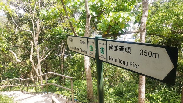
At this point, you will get to a fork. I suggest you first go explore the ancient rock carving on the right.
Once done, you will come back to this fork and keep progressing on the path on the left (2)

There's an explanatory sign on the middle of a promontory. The stairs down to the carvings are on the left.


The 19th century rock-carving
https://www.amo.gov.hk/en/monuments_03.php
Once done, retrace your steps to the fork and keep going

Luk Keng wan in sight.

You will get to this fork. If you feel like going to Luk Keng Wan, head right.
When done, come back here and keep going. You will be climbing to the summit; very painful on a hot day, easy otherwise.

Summit in sight

About 25m before arriving at the building, you will see a path on the left which you must take.
This is the way down from the summit. It is steep and slippery. If you are worried, trace your steps all the way back instead.

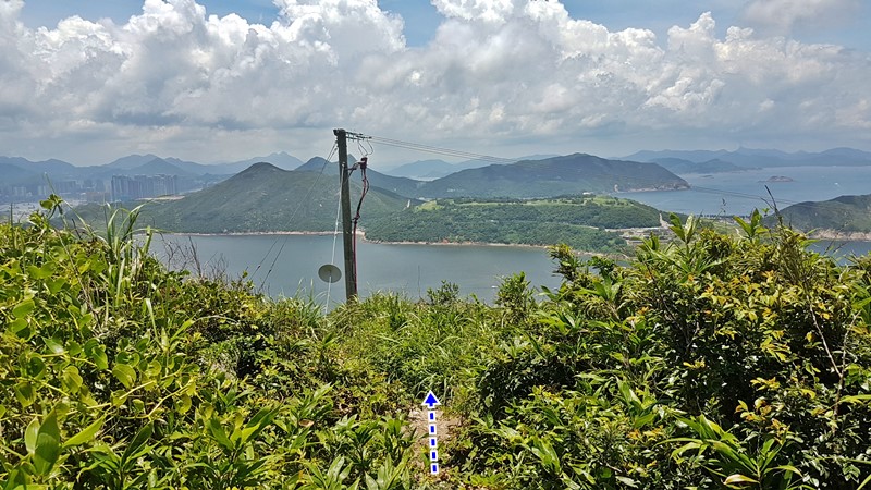
So, you have chosen to continue down the slope. There's a bit of bushwhacking but the path is quite clear and mostly follows underneath the electrical posts. 


The steep portion.

You made it all the way down!


You will reach this path, head right towards a small village where you can get a bit of food and drinks.
From there, you can follow the signs to visit Tung Long Fort (about 300m).
https://en.wikipedia.org/wiki/Tung_Lung_Fort
Once you are done, retrace your steps back to this village...

... and you can go back to the Public Pier by following the sign to 'Rock Carving' about 500m away.

Monday, August 27, 2018

Dai Shek Stream (大石石澗)

Duration: 
10km total. About 1km in the stream

Difficulty: 
10/10. Would strongly advise not to do that stream unless you have a lot of experience stream-trekking, are comfortable with rock-climbing, and will be extremely watchful of loose rocks. There has been a few fatalities on that trek. It is the most dangerous one I have taken part of, due to the loose rocks which can not only cause one to fall, but also, is dangerous for people following. Out of our party of 8, 5 fell or slid during that trek. With one falling about 3 meters.

Cel phone coverage: Sparse.

Water needs: 2 liter.

Appreciation: 9/10. Lots of waterfalls. 


Exercise Area: No.

Transportation: Tsuen Wan West MTR, Exit A1. Bus 51, Shek Kong Village stop. Return via bus 51 at Route Twisk.

Why it's worth it: 

----------------------
Tsuen Wan West MTR. Go out at exit A1 and up to the bus terminus. Take bus 51. 


After about 20-25 minutes bus ride, alight at the 'Shek Kong Village' stop. Then retrace your steps a bit...
… and cross the road as the "path" is on the left side.


After 5-7 minutes walk, you'll see a bunch of small concrete pillars on the left, at a turn in the road, as well as a rain catch.
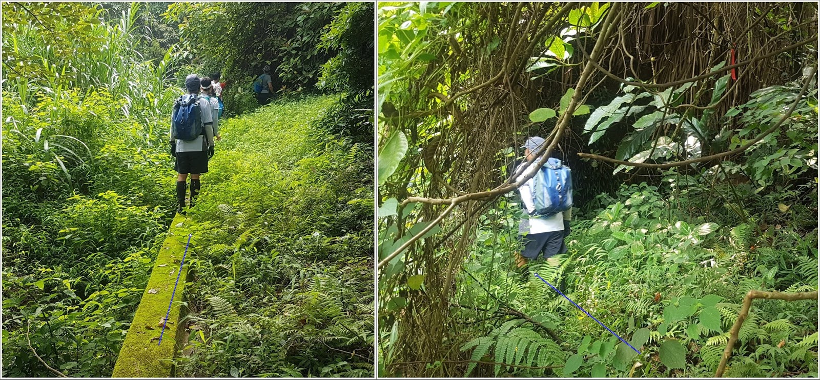
This is where you enter. Walk on the concrete catch.

There's a sign stating the obvious. At this point, if you feel uncomfortable continuing, DON'T !
There is no shame in aborting. Don't be peer pressured.

Keep on the catch-water concrete structure. It will stop, keep straight. You will see a red ribbon, go slightly left.
You should hear the stream.

Refer to the big slanted tree. In any case, the stream is right ahead of you. 
Careful, slippery

Ribbons. Not always very visible because the colors are worn-off

Another catch-water structure on the way down to the stream. 
You are about 30m away from the stream, which you should hear clearly by now.

You should be entering the stream about here. 
No real chance to get lost. Just go up the stream and stay right at any of the forks
Bypasses are generally quite obvious but beware of loose rocks. Always keep 3 points of contact, and test your anchor points; make sure it is firmly secured to the ground and not brittle. Most of the tall waterfalls are bypassed on the right.
Climb on the right of this one. Most of the holds are actually roots
Climbing on the right. This gives you have good idea of the difficulty level.
Still bypassing on the right.
After a few more easier waterfalls, the stream dies out and you basically will be just walking on rocks. Just keep going straight up and you will get out of the woods and close to the top of a hill.
Climb the hill just enough so you can see behind to your right...
… you should see poles/pylons. The trail is there. On a weekend, there should be quite a few hikers there. You may have to bushwhack your way there but it is at most 150m.
You are mostly home-safe! Go right on the path, towards the weather-radar station's dome. Then, follow the path all the way down to Road Twisk (about 5km) where you will see the bus 51 stop which will bring you back to Tsuen Wan/Tsuan Wan West MTRs

Hike Hong Kong Web Site

HikeHongKOng on Facebook

Please, don't litter!

Hiking is about communion with nature. So please pickup after yourself. There's no excuse to leave plastic bags, water bottles or any rubbish on or around the trails; if you managed to bring it, you can manage to bring it back!