Showing posts with label hike. Show all posts

Monday, November 30, 2020

Thousand Islands - Tai Lam Chung Reservoir (大欖涌水塘) - The easy (and crowded) way

Duration:  7.5 km (2:15h)

Difficulty: 4/10. 212m elevation gain.

Cel phone coverage: Everywhere

Water needs: 1 liter. 90% shaded. 

Appreciation: 6/10. The more difficult way to get the Thousand Islands view is also prettier: http://www.hongkonghikes.com/2016/02/thousand-islands-tai-lam-chung-reservoir.html 

Exercise Area: No

Transportation:  Get to Tuen Mun MTR station. Take green minibus 43 in front of the market on Ho Pong Street. Get off at the end in So Kwun Wat Tsuen. Return via green minibus 43 to Tuen Mun MTR station.

Why it's worth it:


-------------------------

Take exit E at Tuen Mun  MTR. Walk through the 'V' shopping center
(head left and go down and the northern-most end)
... walk out and to Ho Pong street, the Green Minibus stop is in front of the market. Take it there.

Upon your arrival in So Kwun Wat Tsuen (that's the final stop before the bus loops back to the MTR), as you get off the minibus, the trail starts on the left of the temple. You will see a sign for Chan Uk Tsuen which shows the way.


About 300m into the hike, you'll get to an intersection at point #2, keep going straight


About 20 minutes (1.15km) into the hike, you will reach this point where the path merges into Maclehose 10. Head right.


Here, you keep going straight on Maclehose 10, leaving the paved road.

Farther down the path, you will reach this point, with a bunch of stairs on your right and a sign stating that this is the way to the viewpoint. You can't miss it, really.

When you are done, just retrace your steps back to the bus stop.


Monday, August 27, 2018

Dai Shek Stream (大石石澗)

Duration: 
10km total. About 1km in the stream

Difficulty: 
10/10. Would strongly advise not to do that stream unless you have a lot of experience stream-trekking, are comfortable with rock-climbing, and will be extremely watchful of loose rocks. There has been a few fatalities on that trek. It is the most dangerous one I have taken part of, due to the loose rocks which can not only cause one to fall, but also, is dangerous for people following. Out of our party of 8, 5 fell or slid during that trek. With one falling about 3 meters.

Cel phone coverage: Sparse.

Water needs: 2 liter.

Appreciation: 9/10. Lots of waterfalls. 


Exercise Area: No.

Transportation: Tsuen Wan West MTR, Exit A1. Bus 51, Shek Kong Village stop. Return via bus 51 at Route Twisk.

Why it's worth it: 

----------------------
Tsuen Wan West MTR. Go out at exit A1 and up to the bus terminus. Take bus 51. 


After about 20-25 minutes bus ride, alight at the 'Shek Kong Village' stop. Then retrace your steps a bit...
… and cross the road as the "path" is on the left side.


After 5-7 minutes walk, you'll see a bunch of small concrete pillars on the left, at a turn in the road, as well as a rain catch.
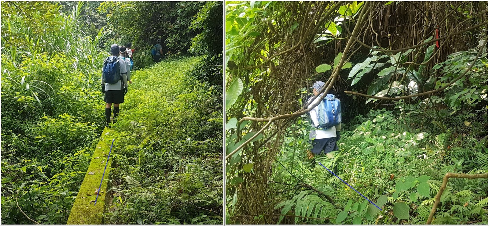
This is where you enter. Walk on the concrete catch.

There's a sign stating the obvious. At this point, if you feel uncomfortable continuing, DON'T !
There is no shame in aborting. Don't be peer pressured.

Keep on the catch-water concrete structure. It will stop, keep straight. You will see a red ribbon, go slightly left.
You should hear the stream.

Refer to the big slanted tree. In any case, the stream is right ahead of you. 
Careful, slippery

Ribbons. Not always very visible because the colors are worn-off

Another catch-water structure on the way down to the stream. 
You are about 30m away from the stream, which you should hear clearly by now.

You should be entering the stream about here. 
No real chance to get lost. Just go up the stream and stay right at any of the forks
Bypasses are generally quite obvious but beware of loose rocks. Always keep 3 points of contact, and test your anchor points; make sure it is firmly secured to the ground and not brittle. Most of the tall waterfalls are bypassed on the right.
Climb on the right of this one. Most of the holds are actually roots
Climbing on the right. This gives you have good idea of the difficulty level.
Still bypassing on the right.
After a few more easier waterfalls, the stream dies out and you basically will be just walking on rocks. Just keep going straight up and you will get out of the woods and close to the top of a hill.
Climb the hill just enough so you can see behind to your right...
… you should see poles/pylons. The trail is there. On a weekend, there should be quite a few hikers there. You may have to bushwhack your way there but it is at most 150m.
You are mostly home-safe! Go right on the path, towards the weather-radar station's dome. Then, follow the path all the way down to Road Twisk (about 5km) where you will see the bus 51 stop which will bring you back to Tsuen Wan/Tsuan Wan West MTRs

Monday, November 20, 2017

Dragon's Back Option 2: MTR and walk to trail. No bus on the way - 龍脊路線選擇2:地鐵,步行到行山徑。 (不乘巴士)

Duration/時間: About 2.5 hours of walking.約2.5小時的步行時間。

Difficulty/難度: About 250 steep steps for the first part which are going to be challenging if you are a beginner, quite easy afterwards.
難度:第一部分將會有大約250級陡峭的樓梯,這對初行山者比較難,稍後會易的。

Appreciation/欣賞: 8/10. First 1/3 of the trail is nothing to write home about. Second third is nice, shaded walk but without much of a view. Last third if breathtaking; amazing views from the Dragon's Back. Shek-O beach.
頭1/3的路程沒有什麼特別。 第二段是舒適,陰涼地散步,但沒有太多景觀。 最後的三分之一,是令人讚嘆的景色。 石澳海灘。

Transportation: http://ptes.td.gov.hk
Garminhttp://connect.garmin.com/activity/411703859

 Why it's worth it/值得你去嗎?:

 -------

Take the MTR to Chai Wan. Take Exit A. You will go through a mall for a few steps, stay on your right and exit at the first outdoor walkway on your right. Go straight at the first intersection on the catwalk.
乘坐地鐵前往柴灣。 出口A。你將通過一個商場,靠右邊走,到第一個到外面的出口(在右邊)。在天橋的第一個十字路口向前走。

You want to go down the catwalk to reach Wan Tsui Road. It is the road which will be to the left of the tall glass building (Youth Square) pictured below.
你要由天橋到下面的環翠道。環翠道是在玻璃建築(青年廣場)的左邊。照片如下。

Walk on Wan Tsui Road for about 200 meters until you reach Lin Shing Road (on your left). 
在環翠道約二百米後便到達連城道(左)。
Take Lin Shing Road :
跟着連城道行:


You will walk about 300 meters on Lin Shing Road until you reach a cross-road and see the Cape Collinson Catholic Cemetery entrance right in front of you. Go through the entrance and take the first set of stairs on your left.
在城道步行約300米,便到達一條十字路口,在面前便是歌連臣角天主教聖十字架墳場入口。 通過入口,在左邊的第一條樓梯向上走。


Walk up the road after this set of stairs...
在樓梯後再向上走

Yep, more stairs!
是的,更多的樓梯!


Quite a few set of stairs to climb-up, don't despair, the trail is worth it!
還有很多樓梯要爬啊! 別絕望,龍脊是值得的!

 
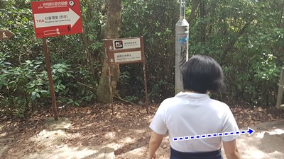
At the top of the stairs, you'll be facing a parking lot slightly on the right and a park on the left. Head right towards the sign post.
在樓梯的頂部,你會見到一個停車場在右邊,左邊是一個公園。 向右朝路牌走。

 Follow the small paved road in the direction of Tai Tam Gap. The rest is pretty easy, just follow the road to the trail (head left). The sign posts clearly show the way.
隨着路向大潭峽的方向走。 其餘的都很簡單,只需沿著路徑走去(靠左)。 標誌牌很清楚的。

 
The first half a the trail is tree shaded and quite nice, with little in terms of view however. Eventually, you will reach a sign post with clear indications for the Dragon's Back. After a little climb, the scenic part of the trail begins.
路線的前半部有樹蔭遮蔽,相當舒適,但視野不大。你將會到達一個標誌牌去龍脊的方向。 經過一小段的斜坡,風景秀麗的小徑便開始了。

At the end of the trail, you arrive right at a bus stop. You can take bus #9 to the Shau Kei Wan MTR station but I suggest you instead take #9 the other way and head to Shek-O for some food and a leisurely walk by the beach.
在山徑的盡頭,便是巴士站。 你可以乘坐9號巴士回筲箕灣地鐵站,但是我建議你乘坐反方向的9號巴士,去石澳吃些東西,在海灘悠閒散步。

Monday, February 6, 2017

Short loop to Sharp Peak (Nam She Tsim - 蚺蛇尖 ) - 上蚺蛇尖 -較短的循環路線

(Updated: 2021-03-25)

Duration/時間: 4.5 hours, 10km. 4.5小時10公里

Difficulty/難度:
8/10. Hands required to climb some of the sections. Do not attempt if you are afraid of heights or don't feel comfortable scrambling. About 450m climb in total.
某些部分需要手攀爬如果你怕高或不不擅長攀爬, 最好不要勉強嘗試 總共攀爬約450m

Cel phone coverage/手機覆蓋: Partial coverage. 部分地方訊號不足

Water needs/建議帶水: 2 liters. 2升

Appreciation/欣賞: 10/10. 
One of the most scenic hikes in Hong Kong.
香港其中一個風景最美的遠足遊

Transportation/交通:
Take bus 96R from Diamond Hill MTR exit C on Sunday or public holidays an exit at Pak Tam Au. Take speedboat or ferry at Chek Keng Pier to Wong Shek Pier and return via 96R.
星期日或公眾假期,從鑽石山地鐵出口C可乘坐96R巴士,在北潭凹下車。回程在赤角碼頭乘坐快艇或渡船至黃石碼頭,再轉96R巴士返回。


Why it's worth it/值得你去嗎?:

Exercise Area: No
------------------------
Take 96R at Diamond Hill MTR station, drop off at Pak Tam Au.The trail head is on your right, across the road.
There are toilets there shall you need them before you start. Have a quick look at my map. Not too hard to get your bearing. That is Maclehose section 2 by the way.
在鑽石山地鐵站乘坐96R巴士,在北潭凹下車。過馬路, 行山的路徑在你的右邊。
起程之前,如需要, 有廁所在附近.  看看我的地圖 , 很容易找到你的方位。這就是麥理浩徑第2段


First fork, go right.
第一個分叉,向右走

Then a left towards Chek Keng
跟住向左走, 往赤徑

At Chenk Keng, hang right. The path on the left goes to goes to the pier and the youth hostel
在赤徑, 轉在.  左邊的路是去碼頭和青年旅館的

Between milestone M40 and M39, about an hour in, you'll reach a little pavilion and a bench. That's where you break-off of Mac 2 and go up towards Sharp Peak. This is where the fun begins. You just have to follow the most direct path to the peak, Can't miss it. And yes, those steep patches are to be climbed...
大約一個小時後, 在里程碑M40和M39之間,你會到達一個小亭子和長凳。 那就是要和麥理浩徑第2段說再見
的地方,挑戰蚺蛇尖。 有趣的攀爬快要開始了。 你只需要遵循最直接, 向高峰路走便可。 是的,那些陡峭的地方是要手腳並用去爬的...

Top of Sharp Peak
蚺蛇尖山峰
On the way back down, you can bypass the first 2 steep pitches. From the top, just continue opposite from where you came from. It is a lot less steep. Then, you get to this point, turn right. A bit of bushwhacking, and you'll be back to the trail.
在下山的路上,你可以繞過首兩個陡峭的部分。 從頂部,只是從你來的地方相反方向走。 這不是太險峻。 然後,你到達這一點,右轉。穿過些叢林後,你會回到小徑。


Keep going until you get in the vicinity of the second scrambling pitch, head down and left instead. Then, there will be another bypass path on your right, as per the picture. You'll end-up right at the foot of the second pitch. You'll still have to scramble down the 3rd pitch but it is a bit easier. Then, it is smooth sailing back to Mac 2, retrace your steps towards Chek Keng
繼續前進,直到你進入第二個險峻的地方,向下走, 再左轉。跟圖片走,右邊會有另一條支路。 你會繞過剛才第二個險峻的斜坡。第三個斜坡你仍然必須小心爬下去,但比第二個容易一些。 然後,應該可以順利回到麥理浩徑第2段,走回頭路到赤徑.

You'll get to those stairs. No signage that indicate anything. Take them and you'll get to the Chek Keng pier.
There are speedboats to take you to Wong Shek pier. $150 to charter one. Wait a few minutes for other hikers to join and make it cheaper
你會見到那些樓梯。 沒有任何指示。下樓梯後,你會到達赤徑碼頭。
赤徑碼頭有快艇帶你回到黃石碼頭。包快艇要 $ 150。 等多幾個行山朋友便更化算! 

Hike Hong Kong Web Site

HikeHongKOng on Facebook

Please, don't litter!

Hiking is about communion with nature. So please pickup after yourself. There's no excuse to leave plastic bags, water bottles or any rubbish on or around the trails; if you managed to bring it, you can manage to bring it back!