Showing posts with label recommended. Show all posts

Monday, November 20, 2017

Dragon's Back Option 2: MTR and walk to trail. No bus on the way - 龍脊路線選擇2:地鐵,步行到行山徑。 (不乘巴士)

Duration/時間: About 2.5 hours of walking.約2.5小時的步行時間。

Difficulty/難度: About 250 steep steps for the first part which are going to be challenging if you are a beginner, quite easy afterwards.
難度:第一部分將會有大約250級陡峭的樓梯,這對初行山者比較難,稍後會易的。

Appreciation/欣賞: 8/10. First 1/3 of the trail is nothing to write home about. Second third is nice, shaded walk but without much of a view. Last third if breathtaking; amazing views from the Dragon's Back. Shek-O beach.
頭1/3的路程沒有什麼特別。 第二段是舒適,陰涼地散步,但沒有太多景觀。 最後的三分之一,是令人讚嘆的景色。 石澳海灘。

Transportation: http://ptes.td.gov.hk
Garminhttp://connect.garmin.com/activity/411703859

 Why it's worth it/值得你去嗎?:

 -------

Take the MTR to Chai Wan. Take Exit A. You will go through a mall for a few steps, stay on your right and exit at the first outdoor walkway on your right. Go straight at the first intersection on the catwalk.
乘坐地鐵前往柴灣。 出口A。你將通過一個商場,靠右邊走,到第一個到外面的出口(在右邊)。在天橋的第一個十字路口向前走。

You want to go down the catwalk to reach Wan Tsui Road. It is the road which will be to the left of the tall glass building (Youth Square) pictured below.
你要由天橋到下面的環翠道。環翠道是在玻璃建築(青年廣場)的左邊。照片如下。

Walk on Wan Tsui Road for about 200 meters until you reach Lin Shing Road (on your left). 
在環翠道約二百米後便到達連城道(左)。
Take Lin Shing Road :
跟着連城道行:


You will walk about 300 meters on Lin Shing Road until you reach a cross-road and see the Cape Collinson Catholic Cemetery entrance right in front of you. Go through the entrance and take the first set of stairs on your left.
在城道步行約300米,便到達一條十字路口,在面前便是歌連臣角天主教聖十字架墳場入口。 通過入口,在左邊的第一條樓梯向上走。


Walk up the road after this set of stairs...
在樓梯後再向上走

Yep, more stairs!
是的,更多的樓梯!


Quite a few set of stairs to climb-up, don't despair, the trail is worth it!
還有很多樓梯要爬啊! 別絕望,龍脊是值得的!

 
At the top of the stairs, you'll be facing a parking lot slightly on the right and a park on the left. Head right towards the sign post.
在樓梯的頂部,你會見到一個停車場在右邊,左邊是一個公園。 向右朝路牌走。

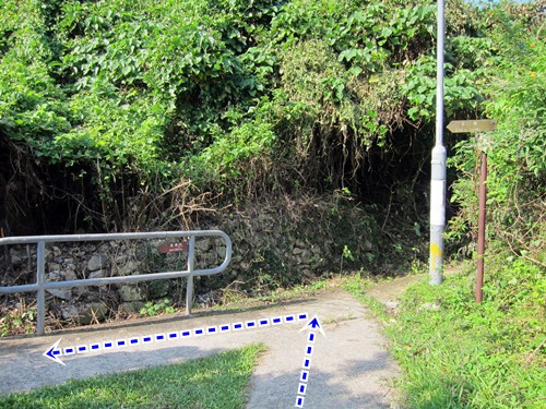
 Follow the small paved road in the direction of Tai Tam Gap. The rest is pretty easy, just follow the road to the trail (head left). The sign posts clearly show the way.
隨着路向大潭峽的方向走。 其餘的都很簡單,只需沿著路徑走去(靠左)。 標誌牌很清楚的。

 
The first half a the trail is tree shaded and quite nice, with little in terms of view however. Eventually, you will reach a sign post with clear indications for the Dragon's Back. After a little climb, the scenic part of the trail begins.
路線的前半部有樹蔭遮蔽,相當舒適,但視野不大。你將會到達一個標誌牌去龍脊的方向。 經過一小段的斜坡,風景秀麗的小徑便開始了。

At the end of the trail, you arrive right at a bus stop. You can take bus #9 to the Shau Kei Wan MTR station but I suggest you instead take #9 the other way and head to Shek-O for some food and a leisurely walk by the beach.
在山徑的盡頭,便是巴士站。 你可以乘坐9號巴士回筲箕灣地鐵站,但是我建議你乘坐反方向的9號巴士,去石澳吃些東西,在海灘悠閒散步。

Sunday, November 17, 2013

Lantau Section 2-3

Duration: 
(11.7 kilometers)
7 hours

Difficulty: 8.5/10. For distance and elevation gain.

Appreciation: 10/10

Transportation: Take bus route 1 from Mui Wo Bus Terminal and get off at Nam Shan stop. To return, there are buses from the Ngong Ping site (Big Budha).

Why it's worth it:


Garmin: http://connect.garmin.com/activity/404810730


---------------------------------------
Not much to say, the trail is well signed and keep looking for the 500m markers. Only point where you may get confused is at the beginning of section 3 (after crossing the road); you must head up and to the right and you'll see a fork a little bit higher up with a flat path on the left and more steps on the right. Go right. Otherwise, you are going on the country trail. If you have never been to Ngong Ping, if you arrive there before 5:30pm, you can climb the steps to say hi to the giant Budha


Monday, July 1, 2013

Mac2 to Sharp Peak (蚺蛇尖)

Duration: 
(15.86 kilometers)
6 to 7 hours
Difficulty: 10/10. Hands required to climb some of the sections. Make sure you print the Garmin map for reference.
Appreciation: 10/10. One if not the most scenic hike in Hong Kong.

Transportation: From Sai Kung, take a cab to High Island Reservoir dam 萬宜水庫 (get all the way to the pavilion). At the end, take a boat from the Chek Keng Hau bay pier to Wong Shek pier.To do on a Sunday so you can take the 96R back to the Diamond Hill MTR.

Why it's worth it:


Garmin: http://connect.garmin.com/activity/335835620
---------------------------------------

The cab should drop you off at the Easternmost part of the High Island reservoir. Right after the principal dam and the pavilion, you'll head left and start climbing.

After 20 minutes or so of climbing up and down, you'll reach Long Ke beach which is  paradisaical and  nicely shaded, making it a nice spot for pic-nics or even camping if you're into it. Once you're done, follow the trail, more climbing and awesome vistas as per photo (Long Ke)


After the 300 meters climb, you'll start going downhill and eventually reach the merging point with the trail that most Sunday hikers take coming from Sai Kung (it is much easier). Head right.

Arriving in Sai Wan village.

Food break or keep going.

Sai Wan beach. The next bit has no shades so it is a bit painful if you do it in the summer and mid-day. 

After 30-40 minutes and a few "wow" moments, you will have reached Ham Tin Wan where you can rest a bit, have some food, restock your water supply and enjoy the beach. The toughest part of the hike is yet to come so, you'll need all the energy you can muster.
Once you are done, go right through the store and take a left.


After this point, it's all quite obvious; just follow the trail. It is not a steep climb but it keeps going up for about 50 minutes with not much in terms of nice views as rewards for a job well done.


About a 2km walk up from Ham Tin beach (between M039 and M040), you'll reach a bench at the top of a hill with a this sign which describes Sharp Peak. At this point, you must decide if you still have the energy to tackle it because it is going to be a strenuous 2km up, followed by a no-less strenuous 2km down which will bring you back to this very same location you are now at. The path to Sharp Peak is pretty obvious but quite hazardous. If you don't feel good about using your hands to climb some of the sections, don't go.
On the way back, keep going on Maclehose section until you reach M042. There should be a set of stairs going down on the right towards the bay and a path will lead you to the pier where boats can take you to Wong Shek pier. It costs $150 to charter the boat so if you are alone , wait for other hikers to join you so the price can come down to something more reasonable. 

Sunday, February 24, 2013

Mui Wo to Sunny Bay


Appreciation: 9/10. Very scenic. Lots of up and down and no shades so, probably not the best for mid-summer. 

Why it's worth it: 


Duration: 
15k
800m elevation gain 
Total: 4 hours 30 min

Garmin GPS route: http://connect.garmin.com/activity/276881713

Difficulty: 
7.5/10. Slippery at places. Bushwacking at times; trail might not be visible at all.

Cel phone coverage: Partial.

Water needs: 2 liters.

Transportation: Ferry to Mui Wo (Pier 6 in Central). Sunny Bay MTR to return.

--------------------
Off the Mui Wo ferry, head right, following the water.


Get to Silvermine beach
Towards Silvermine falls

About at Silvermine falls
Right at the modern gazebo.

Again right

You will get the trail markers for a while

At this point, is pretty much a single trail. Can't get lost.

Going by Discovery Bay
Intersection, go straight. Off the beaten path.
Disco Bay again, in the back.

Bushwacking. The path was still very obvious though. Rely on the Garmin map if it isn't.


About 3 or so hours in. Full-view of the land of Mickey.


Sunny Bay MTR in sight. Be careful on the way down.


Turn left, towards the uninhabited building


Right of it...

... through the gates.

Here, 2 options, if you head right, there's a tunnel underneath the highway. Head left (that's the path we took), you'll have to cross one section of the highway (just a one-way and there's not a lot of cars)

Green path on the right, blue path on the left. They merge on Sunny Bay road. Then do the little loop, under the  Noth Lantau highway, on you are there at Sunny Bay MTR.

Hike Hong Kong Web Site

HikeHongKOng on Facebook

Please, don't litter!

Hiking is about communion with nature. So please pickup after yourself. There's no excuse to leave plastic bags, water bottles or any rubbish on or around the trails; if you managed to bring it, you can manage to bring it back!