Showing posts with label mountains. Show all posts

Sunday, March 31, 2019

High Island Reservoir (萬宜水庫; maan6 ji4 seoi2 fu3) to Sai Kung beaches

Duration: 
13km (4.5 hours)

Difficulty: 
6/10. 568m elevation gain. Sun exposed throughout 

Cel phone coverage: Partial.

Water needs: 1.5 liter.

Appreciation: 10/10. Best combination of beaches and mountain views. Hong Kong Geopark at the beginning. Fishing villages at the end.


Exercise Area: No

Transportation: Take a taxi in Sai Kung, in front of the 7-11 and ask the driver to get you to High Island Reservoir (萬宜水庫; maan6 ji4 seoi2 fu3). Return to Sai Kung via bus 92 at Wong Chek pier, or bus 94 all the way to Diamond Hill on Sundays & public holidays.

Why it's worth it: 


-----------------------------------------
High Island Reservoir (萬宜水庫; maan6 ji4 seoi2 fu3). This is where the cab will drop you off. You can spend a bit of time going down to check-out the Hong Kong GeoPark's rock formations. When done, head left to the trail. 

About 35 minutes later, you will arrive at the first beach, Long Ke Wan. Keep going on the path which has been a bit beaten up by typhoon Mankut. The trail goes up the mountain and you'll get this view of Long Ke Wan if you look back

About 4km and 1.5 hour into your hike, you'll reach this point where you can admire, in order, Sai Wan, Ham Tin, and Tai Long beaches... 

You will then hike back down for another 40 minutes to this crossroad with a map. Head right and down towards Sai Wan


Sai Wan (little beach)

The path going up after Sai Wan is quite clearly demarcated.
You may want to cross the bridge on the left if water level is high 
After 8km and 3.5 hours, you'll be about at this point, overlooking the wonderful Ham Tin beach!


Rest for a while at Ham Tin beach, have a bit to eat, then when done, go through the store and head on the path to the left. Then just follow the path for about another 50 minutes (3km)

Exactly at trail marker M042 (encircled on the picture), you will see stairs on your right. Take them and follow the path to the Sha Tau pier. You can take a fast boat to Wong Shek pier where the bus terminus back to Sai Kung is.


Sunday, December 4, 2011

MacLehose Section 3


(Updated 2019-APR-22)
Duration: (10.2k) Between 4 and 5 hours depending on walking speed (took us 4)

Difficulty: 8/10. 586m elevation gain. There are two steep climbs but each time, they are no more than 25 minutes long.

Cel coverage: Sparse to none

Water needs: 1.5 liter

Appreciation: 8/10. The views are nice, although most of the same as Section 2, but without the beaches. 

Maps and details: http://www.mapmyhike.com/workout/2791504142

Exercise area: None

Transportation: Better go on a Sunday as the other days make transportation harder. From Diamond Hill MTR station, KMB 96R will take you directly to Pak Tam Road where you get off at 北潭凹 PAK TAM AU stop. Otherwise, you can take bus 92 to Sai Kung, then 94 to Pak Tam Au stop. At the end of section 3, return taking bus 299 or 99 to Sai Kung, then 92 to Diamond Hill. Note that the bus stop is not right at the trail end; you will have to walk 5 minutes on your right or left.

Relive.cc: 


-------------

The bus will drop you off right by the trail head.

Quite straightforward and with good signage.

Around post sign 52, there might be some confusion as there seems to be some trail going to the left.
That is not Maclehose. Keep right! (follow the sign)

At M055, there's a camping site and a map if you are unsure which way to go.
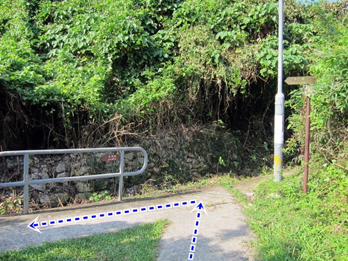
But basically, sharp left as indicated above.

Around M056. Keep left towards Shui Long Wo.


Monday, November 28, 2011

MacLehose Section 1 & 2

(Updated 2020-DEC-19)
Duration: 
(24.1 kilometers)
Section 1: Between 2 and 3 hours depending on walking speed (took us 2)
Section 2: Between 3.5 and 5 hours, depending on walking speed (took us 3.5)

Difficulty: 
7/10. Section one is a road, 90% flat. Really easy. Section 2 has some more challenging hills. About 300 meters ascent. 30% shaded.

Cel phone coverage: No.

Water needs: 2 liters.

Appreciation: 10/10. The views are incredible, especially in Section 2. Long Ke beach really, really nice.

Map & Details: 
https://www.hiking.gov.hk/trail/info/id/VFFUbFFNOXNXTHNWU2FqT09UTjlOZz09/map_type/1#route_map
https://www.hiking.gov.hk/trail/info/id/d0pFSWc1N1dWdkh3aStSajBvUHlmUT09/map_type/1#route_map

Exercise Area: No

Transportation: From Diamond Hill MTR station, KMB 96R will take you directly to Tai Mong Tsai Road where you get off at Pak Tam Chung stop (Sundays and Public holidays only). Otherwise, you can take bus 92 to Sai Kung, then 94 to Pak Tam Chung stop. Return is even easier as section 2 ends almost right in front of a 94/96R bus stop.

Why it's worth it: 


-------------

96R at Diamong Hill MTR station. Very busy on Sunday mornings!


Pak Tam Chung stop bus stop.

Walk about 100 meters and head right. That's MacLeohose's trail head.
Click for larger version. All the spots marked with a number are referenced in the photos that follow.

Just follow the road. With nice vistas on your right...

... and on your left.

Not very complicated but just in case...

Head left.

Ain't that beautiful?

Right after the principal dam and the pavilion, you'll head left and start climbing.
At this point, you have cleared MacLehose Section 1. Go checkout the dam however, worth a few extra steps.

After 20 minutes or so of climbing up and down, you'll reach Long Ke beach which is  paradisaical and  nicely shaded, making it a nice spot for pic-nics or even camping if you're into it. Once you're done, follow the trail, more climbing and awesome vistas as per photo (Long Ke)


After the 300 meters climb, you'll start going downhill and eventually reach the merging point with the trail that most Sunday hikers take coming from Sai Kung (it is much easier). Head right.

Arriving in Sai Wan village.

Food break or keep going.

Sai Wan beach. The next bit has no shades so it is a bit painful if you do it in the summer and mid-day. 

After 30-40 minutes and a few "wow" moments, you will have reached Ham Tin Wan where you can rest a bit, have some food, restock your water supply and enjoy the beach.
Once you are done, go right through the store and take a left.


After this point, it's all quite obvious; just follow the trail. It is not a steep climb but it keeps going up for about 50 minutes with not much in terms of nice views as rewards for a job well done. 

At this point, don't go straight, keep on the path. You are about 25 minutes away from Tai Mong Tsai road and the end of Section 2. Once at the road, the bus stop will be on your side of the road and to the left.
Congrats on completion of MacLehose Section 1 & 2. Please note that section 3 starts just across the road, should you be tempted to go on.


Hike Hong Kong Web Site

HikeHongKOng on Facebook

Please, don't litter!

Hiking is about communion with nature. So please pickup after yourself. There's no excuse to leave plastic bags, water bottles or any rubbish on or around the trails; if you managed to bring it, you can manage to bring it back!