(Updated 2019-APR-22)
Duration: (10.2k) Between 4 and 5 hours depending on walking speed (took us 4)
Difficulty: 8/10. 586m elevation gain. There are two steep climbs but each time, they are no more than 25 minutes long.
Cel coverage: Sparse to none
Water needs: 1.5 liter
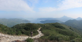
Appreciation: 8/10. The views are nice, although most of the same as Section 2, but without the beaches.
Maps and details: http://www.mapmyhike.com/workout/2791504142
Maps and details: http://www.mapmyhike.com/workout/2791504142
Exercise area: None
Transportation: Better go on a Sunday as the other days make transportation harder. From Diamond Hill MTR station, KMB 96R will take you directly to Pak Tam Road where you get off at 北潭凹 PAK TAM AU stop. Otherwise, you can take bus 92 to Sai Kung, then 94 to Pak Tam Au stop. At the end of section 3, return taking bus 299 or 99 to Sai Kung, then 92 to Diamond Hill. Note that the bus stop is not right at the trail end; you will have to walk 5 minutes on your right or left.
Relive.cc:
Relive.cc:
-------------
 |
| The bus will drop you off right by the trail head. |
 |
| Quite straightforward and with good signage. |
 |
| Around post sign 52, there might be some confusion as there seems to be some trail going to the left. That is not Maclehose. Keep right! (follow the sign) |
 |
| At M055, there's a camping site and a map if you are unsure which way to go. But basically, sharp left as indicated above. |
 |
| Around M056. Keep left towards Shui Long Wo. |


