Duration:
(5 kilometers)
3 hours taking short option
4 hours taking long option
Difficulty: 7/10
Cel phone coverage: Everywhere
Water needs: 1.5 liter. Please, do not litter!
Appreciation: 7/10. First 2/3 of the stream is nondescript. A few very nice waterfalls in the last part. Lots of spider nets and flies make the trek a bit annoying. There are much better streams to trek in Hong Kong
Transportation: MTR to Tsuen Wan West station (Exit E1). KMB bus 51, dropping off at Chuen Lung (bus display was calling it Tsuen Lung). Return the same way.
Why it's worth it:
---------------------
 |
| At Tsuen Wan West MTR station, get out at Exit E1, then find bus 51's platform on the right |
LONG OPTION
 |
| Get off at Chuen Lung stop (it was listed as Tsuen Lung on the bus' electronic board). Backtrack a few meters and take the road through the village |
 |
| After a few hundred meters walk, you'll reach a metal bridge. On your right, you'll see service stairs going down to the stream, take them and go upstream, on the left. |
 |
| A few of the lower falls. Quite small. |
 |
| After about 50 minutes, you'll eventually reach the bridge which you can reach by foot with the short option |
SHORT OPTION
 |
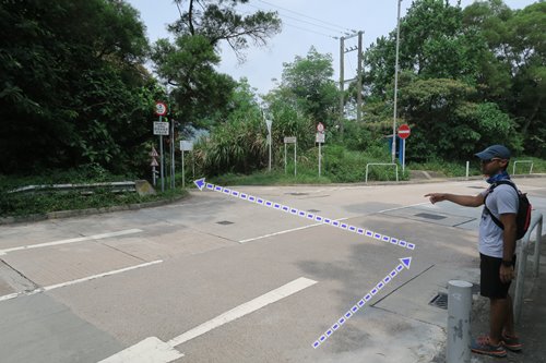
| Get off bus 51 at Chuen Lung (Tsuen Lung). Then keep walking up the road until 20m before you reach a sharp left turn in the road, you'll turn into the road on your right. Don't go all the way to the turn itself which has the Rotary Park Nature Trail trail head. |
 |
| Right after you turn into the road, you'll see 3 paths about 20m into the road. Take the one on the left. Not sure whether the container will still be there but it's the first path on the left. It is a 5 minutes walk to the bridge where you enter the stream |
 |
| There are a lot of side-paths but most of them lead to houses. Just stay on the main path |
 |
| Eventually, you'll get here. View of the mountains on the right. Some kind of a large rock on the left of the path. You're 30 seconds away from the stream |
 |
| This is the bridge where you enter the stream |
REST OF THE STREAM
 |
| Along the way, the stream will split a few times. Don't worry as it merges again after a few meters. There's only one turn you must make further down the stream, but that's about 2 hours into it |
 |
| 2 to 2.5 hours into the stream, you'll get here where you actually have to go the right way... to the right. The branch on the left won't easily connect you to the exit path. What seems to be a little waterfall on the right is actually a 5m waterfall with a nice little pool at its feet... |
 |
| ...that's the waterfall. Can be bypassed on the left |
 |
Nice waterfall
|
 |
| You'll eventually arrive to a waterfall that tumbles over a very flat rock surface. You'll recognize it when you see it as it (left on the picture), it's quite unmistakable. Bypass on the right |
 |
| 10 minutes or so later, you'll reach this waterfall and the path keeps going on the left. Don't try to follow this waterfall's stream branch on the right. The correct was is on the left where you can sort of see a large waterfall at a distance |
 |
| This is the tall, 10m waterfall that can be seen from the previous spot. It is too dangerous to scale directly. There's a path on the left and there should be a rope to help you climb the steeper portion of the path. You still have 15 minutes to go to reach the end of the stream |
 |
| 15 minutes walk later, you'll get to the bridge. It crosses the stream so you can't miss it |
 |
| Head right. Lots of flies around there |
 |
| Keep on the path until you reach a set of stairs and a sign that indicates that stairs go to Chuen Lung. Take the stairs |
 |
| Nice views along the way |
 |
| You'll re-join the path after the nature trail bypass |
 |
| As per the map, you'll reach a sharp 180 turn in the path. About 30 meters after, there will be a path on your left which is a straight shortcut to Chuen Lung village. The path might be overgrown and is a bit steep. But it will save you 40 minutes |
 |
| That bushwhack path will cross the proper path again. Just go straight through and down. You'll get to Chuen Lung in about 10 minutes. Find your way back to the 51 bus stop which is just across from where you were dropped-off on your way in |