Saturday, June 14, 2014

Eagle's Nest Nature Trail (鷹巢山)

Duration: 
(4 kilometers)
1.5 hours

Difficulty: 3/10. Real easy, shaded walk.


Cel phone coverage: Everywhere.

Water needs: 0.5 liters

Appreciation: 7/10. Nice views of Kowloon and Hong Kong Island. Occasional monkeys. A relaxing little walk.

Transportation: Bus 81. I took it close to the Prince Edward MTR station. Get off at SHEK LEI PUI RESERVOIR bus stop. Return the same way.

Why it's worth it:


---------------------------------------
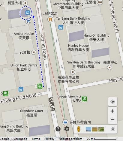
Prince Edward MTR station, Exit 'E', left on Nathan road, right out of the exit.
Lots of buses stop here. 81 should be going by every 15 minutes or so


You will be getting off at 
石梨貝水塘
SHEK LEI PUI RESERVOIR stop.
Then keep walking for about 20 meters,
then take the pedestrian overpass.
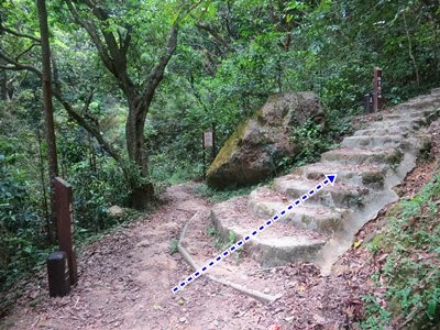
You really can't get lost; just follow the signage for Eagle's Nest Nature Trail.

The trail proper starts and ends here. You start on the left.


That's almost at the end. Quite easy, all shaded.
Perfect for a quick morning hike even when it is hot and humid.

A few of these guys too. Once you have looped back to the trailhead gate, just take bus 81 on the side of street opposite to where you were dropped-off.

Tuesday, June 3, 2014

Lai Chi Wo ghost village (荔枝窩) - Bride's Pool to Kai Kuk Shue Ha (雞谷樹下) / Luk Keng

(Updated:2021-03-07)

Duration: 
(16 kilometers)
5 hours

Difficulty: 5/10. For 473m elevation gain and longer distance.

Cel phone coverage: Sparse. Full in Lai Chi Wo.

Water needs: 2 liters

Appreciation: 7/10. For the Feng Shui practitioners and history buffs. 

Map & Details: 

Transportation: Tai Po Market MTR, Exit A3. Take bus 275R on Sunday or public holidays all the way to the Bride's Pool terminus. Return to Fanling MTR station via minibus 56K.

Why it's worth it:


---------------------------------------
Drop-off at Bride's Pool stop. Cross the road and go down the stairs next to the pavilion.


Bridal's Pool area map

Go down by the picnic areas, over the stream and towards the other picnic area. You'll get here (point 'A' on the map above). If you want to skip the waterfalls and just head towards Lai Chi Wo, go right and up. I suggest you check the waterfalls out though. The map above shows you the waterfall loop from the park's entrance. Go over the bridge on the left (pic right above), then immediately on the path right and up. This leads you to Mirror Pool. When done, retrace your steps and keep going on the path opposite the bridge. The path will split. Do not follow the Bride's Pool sign as that path goes on top of the waterfall. Head left instead and walk until you can see another bridge on your left and a path ahead of you that parallels the stream. Take that path until it merges into the stream. Scrambles in the stream towards the falls in the same direction. You'll be there in 5 minutes. When you are done, retrace your steps to point 'A' and take the path going up.

You'll reach an intersection, go left and up on a path that zig-zags up.


Right after the zig-zag climb, you'll get to this intersection.
Head left (I recycled our model, Anthony, from another hike's picture-set). Keep walking on that path. You'll hear the sound of the Mirror Pool waterfall on your left. Eventually, you'll reach the big "Plover Cove Country Trail" sign  next to the Plover Cove Country Trail which goes up. Don't take it, keep going straight. 

After another 100 meters or so, you'll get to a bridge and you will see the village of Wu Kau Tang at a distance.
Take the path on the right towards the village.


Walk towards the gate and then head right.
Take the first path on the right. The sign says "KAU TAM TSO" 


Right
After about a 500m, you'll reach an intersection, head left (1st on the map above)

At the second intersection (2nd on the map above), keep on to the path on the right.
Afterwards, the path is pretty clear for the rest of the way to Lai Chi Wo.

Mangroves. Pay attention to the water, you might see some little crabs...

Go straight. You can also go to a restaurant 100m on the left for a short water and food break


There are food/water spots along the way. Grass jelly is pretty refreshing too


At this point, signage will lead you straight to Lai Chi Wo

Arrived! At the sign, take 5 minutes to climb to the observation deck, then back down and then keep going straight

View of Lai Chi Wo from the observation deck

Trees in Lai Chi Wo

The interpretation center with Chinese and German speaking host!

Aaaaaah!

Once you are done visiting the village proper, circle it from the right on a path that goes up. You'll see all those 'famous' Banyan trees. 

Once you are done. Follow the path out of the village towards Luk Keng

Follow signs towards Luk Keng

When there's no Luk Keng signs anymore, follow the Kuk Po ones

Left here. 


At one point, you'll reach the Starling inlet, right in front of you. There will be a little restaurant and an intersection. Take a left. You'll be walking by the Starling inlet on your right for about another 1k before you reach the first "village".


Bus 56k to Fanling station is right by a concentration of restaurants.
Hope you had a great hike!

Monday, May 26, 2014

Tai Tam to Quarry Bay via Sheung Tam Stream (雙潭石澗)

(updated 2022-03-11)
Duration: 
(11 kilometers)
4.5 hours

Difficulty: 7/10. 592m elevation gain

Cel phone coverage: Everywhere.

Water needs: 1.5 liter

Appreciation: 9/10. Great stream after a downpour, and great views of Victoria Harbour

Transportation: Sai Wan Ho MTR, Exit A. Take bus 14 and exit right after the dam. Return via Quarry Bay MTR.

Why it's worth it:


Map & Details: 

Exercise Area: No

---------------------------------------
The bus stop to Tai Tam is right off Sai Wan Ho MTR, Exit A. About 25 minutes ride.
Ring the bell when you're on the Tai Tam dam (there's just one on the way). Stop right after the dam.

Beginning of the trek is right across the bus stop.  

It starts with a nice and gentle paved hike.

Head left right before the bridge.

Then right and down.

You'll go by this dam. There's a path going up on the other side of the walkway.

About 20m into that path, it curves to the left. Take the offshoot path to the right and get into the stream. 

Lots of places to swim if you feel like it on a warm day.

This first stream ends about 100m before the dam. There's a picnic area on the right on an elevated stone area.

After a short break (maybe a snack). Head left on the path.


Left after the dam's bridge

Follow Wong Nai Chung Gap Road

At this point, head right and down. You are going towards the second stream

Don't enter the stream on the first waterfall on the left. The stream to enter is about 10-15 minutes walk further along the path.

That's the stream you will enter, at the end of the footpath. Just don't enter it right away a go up behind the sign and you'll see the entry point to the stream a few meters up.
There's one big waterfall and a few nice pools.

This is the end of the second stream. Go up the stairs and onto the road.

You'll see the ParkView estate on your right. Walk towards it.

Then, back on a bone fide trail. On your right, you can't miss the entry point to the Wilson Trail.
That's where you are going. 


Whenever there's an intersection, keep following the Wilson trail signs

Follow this little guy

At one point, you'll reach somewhat of an open-air temple. At this point, just go straight, you no-longer are following the WIlson trail. From this point on, just keep going towards the city. You can't really get lost. Once you reach the town, Quarry Bay MTR is on your left, Tai Koo MTR on your right, pretty much at equal distance.
Hope you liked your hike!

Hike Hong Kong Web Site

HikeHongKOng on Facebook

Please, don't litter!

Hiking is about communion with nature. So please pickup after yourself. There's no excuse to leave plastic bags, water bottles or any rubbish on or around the trails; if you managed to bring it, you can manage to bring it back!