Monday, May 28, 2018

Discovery Bay (愉景灣) to Inspiration lake (迪欣湖) & Disney

Duration: 
8k to Inspiration Lake, 10k to MTR, 3.5 hours

Difficulty: 
7/10. 455m elevation gain. Some steep ascent and descents

Cel phone coverage: Everywhere.

Water needs: 1.5 liter.

Appreciation: 9/10. Nice views of Victoria Harbour, Inspiration lake, etc. 

Exercise Area: No.

Transportation: Ferry to Discovery Bay. Return via Disney MTR.

Why it's worth it: 


----------------------
Right off the ferry, just take the path that follows the sea-shore on the right


The path at this point is next to the beach on your right. 
There will be an opening on your left (about 250m from the ferry pier). Take it.

Go all the way to the end of that street and head right. You will be walking on this road (Discovery Bay rd) for about 1km

At this point, turn left and go between the gray building (Greenbelt Court), and the blue one (Neo-Horizon).

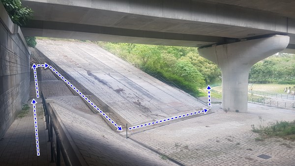
The way up is right behind the buildings, on your left. It is a water catchment

Go up the water-catchment, there will be a dirt path after for your to follow. 
It is steep and may be slippery

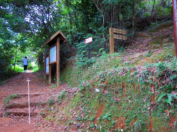
At the top, after about 500m of climbing, you'll take a right at the fork...
… from that point on, only one path that you will go up, and down, then up, then down... a few times... for about 4km...

...until you reach the top of Tai Shan. You are marveling at Inspiration lake on the right, and the Disney resort further on the right.
Once you are done, from the trigonometric point, follow the path that goes down on the left. It is quite clearly defined so there shouldn't be a problem.


Head right

Still right...

Go under the freeway
Update: that way is blocked later on. You may have to walk along the freeway to the roundabout and Inspiration lake.

Up the stairs, down the stairs, and around the fence on the left...

… to the first set on stairs on your left that will let you go over the train tracks.

Right here. Back down right after


You will have the train tracks on your right and the freeway in front of you. 
Go underneath the freeway, following the train tracks. You will see the lake on your left after.
Update: There are security guards posted there now so you probably won't be able to go that way

About 200m after the freeway underpass, you'll see a door on your left which will likely be locked. Next to it on the left, the fence has an opening that should be large enough to let you through. 

Inspiration Lake. Best things in life do seem to sometimes be free!

If you walk along the path on the left, you'll get to this man-made waterfall. 
Once you are done, you can go either way around the lake to get to the pavilion at the other end of the lake

From there, just follow the signs towards Disneyland Park. It is about 1.5km walk


If you don't want to visit Mickey, just head to the MTR

The MTR will bring you to Sunny Bay, then to 'Modern Hong Kong' !

Monday, March 12, 2018

Ng Tung Chai (梧桐寨) to Shing Mun reservoir (城門水塘) via Tai Mo Shan (大帽山)

Duration: 
10k, 4 hours

Difficulty: 
7/10. 635m elevation gain. 

Cel phone coverage: Very sparse.

Water needs: 1.5 liter.

Appreciation: 10/10. Nice forested hike, tons of waterfalls, views from Tai Mo Shan. 

Exercise Area: No.

Transportation: MTR to Tai Wo, exit A. Bus 64K. Return to Tsuan Wan MTR via minibus 82

Why it's worth it: 

--------------------------------


Take Exit 'A' (Tai Wo Plaza) out of the Tai Wo MTR station. Head left.

There will be a set of escalators on your right, leading to the bus stops.

The KMB 64k stop is on the other side of the first road lane. Don't go all the way on the other side because you'd take the 64k to Tai Po Market.

Yeah, that one...

The bus stops just in front of the Ng Tung Chai road (the stop is actually called Ng Tung Chai so, you can't miss it)

Keep following the road, don't be tempted to stray. You'll be walking on that road to Ng Tung Chai for about 10-15 minutes.

When you are in the vicinity of Ng Tung Chai, you will see a path heading up (to the right). Take it.

Go by the front of the house of barky dogs.

Go straight to the rock-paved path. This will lead you to the temple. About 20 minutes walk there.

At the temple, keep going straight. The trail officially starts there.

Don't take the Scatter Fall path. There signage announcing the falls so you can't miss them.
The bottom fall is about 35-40 minutes in.

Bottom fall
Middle fall
Main fall. The tallest in Hong Kong at 35m. Once done contemplating, take the path up and to the left of the falls.
After some scrambling, you'll come to Scatter falls. 
About 4.3km into your hike, you'll reach this fork. On the right, you would loop back to temple.
Take left towards Tai Mo Shan where the fun is!
Bamboo forest... nice!
Walk another 200m, you'll reach another fork. Take the path on the left
You have reached the highest point of your hike.
Not quite the top of Tai Mo Shan, which you can see on your right, but still..
Once rested, find the unmarked path down the mountain, pretty much across from the path you came from. It may be a bit overgrown but don't worry, that's the right way. There should be some colored ribbons along the way
Right at the fork. You'll cross a stream just a few tens of meters farther. Head left after the stream.
I won't point them out here because they are not super obvious and don't want you to get lost, but there are quite a few more waterfalls that can be reached from that path (refer to the Tai Shing stream trek)
Head right at the gate. Left will also get you there but my hiking party was a bit tired at this point.
Down, around, and right
Down left, and then through the picnic area.
Down the stairs, head right. Over the bridge, then right again


That's it, minibus stop which will bring you back to Tsuen Wan


Sunday, March 4, 2018

Tai Wai to Kowloon Tong via Wilson, a forested path, and Lung Yan Rd

Duration: 
9k, 2:45 hours

Difficulty: 
4/10. 369m elevation gain. 

Cel phone coverage: Everywhere.

Water needs: 1 liter.

Appreciation: 7/10. Nice & easy forested hike. 

Map & Details: http://www.mapmyrun.com/workout/2741628367/

Exercise Area: Yes. Chin up and parallel bars.

Transportation: MTR to Tai Wai, exit F. Return from Kowloon Tong MTR

Why it's worth it: 
-------------------------------
Get out at Tai Wai MTR station exit F, head right just out of the exit.
Get on the elevated walkway to cross Hung Mui Kuk road


Then go down onto Hung Mui Kuk road (sidewalk on the left), heading South

After about 15minutes walk from the MTR, you'll get to this point. Take the road that parallels Hung Mui Kuk and goes up.

End of the road finishes in a squatter village. Go through it on the path on the right.

Up the stairs that connect back to Hung Mui Kuk road, then head left.

Cross the road. Go by the bus stop, cross the road again, then walk under the bridge.

Take the stairs on your right, just after the bridge

Go through the BBQ site. There's just one path

About 35 minutes and 1.8km into the hike, the path will go up a few stairs, then cross Wilson Trail Section 5 / Hung Mui Kuk Nature trail. head right onto Wilson Trail

After another 20 minutes walk or so (about 1.1km), you'll reach a bridge with metal fence, and a smaller bridge on your left.
Take the bridge and right after, head right (don't take the path that goes up on the left) 

Go over these. They, right after, it seems like the path splits. On the left, you'll see a small metal structure which might have held a sign in the past, that's where you want to go!
You then follow that path which will have you climb a few steep steps but over just 20m or so. Then the path is nice and forested, taking you through some bamboo forest

About after another 50 minutes walk, you'll reach these steps on your left. Take them

After quite a bunch of concrete steps, you'll reach Lung Yan Road. There's a map at the top of the steps on Lung Yan rd. Head right on Lung Yan Road

You'll then be taking the first major road on your right

A few more hundred meters and you'll reach this convoluted highway roundabout thingee.
Just go to your right where you connect to the road (1st picture), then follow to the left.
Cross at the 2nd crossing. Head left and follow the hairpin turn clockwise and underneath the bridge...

... you will reach this bus stop. If you have a suitable bus to bring you home, you are done. However, if you want to keep going to Kowloon Tong, go around the fence by the stairs, then left...

... then take the stairs down while noticing how people are disgusting; throwing their garbage all over the place.
At the bottom of the stairs, head left. You will have to jump over the catchwater and you will see a dirt path in front of you that you must take. 

Then the path goes along the catchwater. You can walk down atop the concrete sides of the catchwater

A 100m of so farther and you'll reach Beacon Hill rd. Head right.

Head left when you reach Cornwall road. You'll see the red and white MTR sign showing the way to Kowloon Tong MTR station

Almost there!

Hike Hong Kong Web Site

HikeHongKOng on Facebook

Please, don't litter!

Hiking is about communion with nature. So please pickup after yourself. There's no excuse to leave plastic bags, water bottles or any rubbish on or around the trails; if you managed to bring it, you can manage to bring it back!