Tuesday, March 3, 2015

West Dog's Teeth (Kau Nga Ling - 狗牙嶺)

(Updated: 2021/01/02)
Duration: 7.5 kilometers (4 hours)

Difficulty: 8/10. There's scrambling so if you are afraid of heights, not a good one for you!

Cel phone coverage: Everywhere

Water needs: 1.5 liter. 20% shaded.

Appreciation: 10/10. Very scenic

Transportation: MTR to Tung Chung, then bus #11 or #23 (gets quite busy on weekends). Or ferry to Mui Wo, then bus #1 or #2. Get off at "Shek Pik Police Station" (Police stand. Right before the dam. Or, next one right after the dam if you missed it. There are toilets right after the dam)
Return via various buses at Big Buddha or via cable car to Tung Chung.

Why it's worth it:


Map & Details: 


Exercise Area: No
---------------------------------------
Get off at "Shek Pik Police Station" (police stand). That's the stop right before the Shek Pik reservoir.

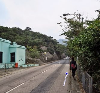
From the stop, retrace your step in the direction the bus came from (so, opposite the dam). There's a sidewalk all the way on the left.

After about 500m, you'll arrive at the Country Park entrance.
Go past the barrier and keep walking towards the first bridge, about 100m away

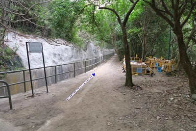
Take the bridge and just follow the path. There's no really any other way but for the well delimited path

Some stairs... keep going... the path will meander. 


About 1 hour into the hike (~3.3km), you'll arrive here. That's where you leave the path and start your ascent on the "teeth" proper (the ridge). On your right, there's a red sign warning not to climb the rock, danger, blah blah, and white markings on the rock. Well, that's where you're climbing buddy! The next 500m or so is quite heavy scrambling. 

The rest is pretty straightforward; while there's no "official" path, the ground is beaten from the many hikers that have taken it and you won't get lost. Furthermore, you're on the ridge so, there isn't anywhere else to go. Look back from time to time as it is very picturesque!


Final destination (Da Big Budha/Ngong Ping) will be on your left while you're climbing the ridge


This is the rock formation that will mark the end of your climb for today.

About 5.3km/2h 40min in, you are virtually done climbing (just a tiny bit more, and easy).
Keep going towards the top, don't take the path that is going down. The rock that you see up at a distance...

... is this rock. You are done climbing. And you are now on Lantau trail.
The stairs on your left will lead you to Ngong Ping, the end of your trip. There are a lot of stairs though...

Almost at the end. Go straight

Budha in sight. Buses and the cable-car are not far behind.
A superb trail!

Sunday, February 8, 2015

Tung Chung to Discovery Bay (via Tiger Head Lo Fu Tau/老虎頭)

Duration: 
(12 kilometers)
3.25 hours

Difficulty: 6.5/10. Not very difficult except for the last descent which can be a bit treacherous. Do not go if it just rained. Good shoes are a must. 

Cel phone coverage: Everywhere

Water needs: 1.5 liter

Appreciation: 6/10. First half is boring. Second half is very scenic.

Transportation: MTR to Tung Chung. Return via ferry or various buses.

Why it's worth it:

Garmin: http://connect.garmin.com/modern/activity/692426783
---------------------------------------
Get out at Exit 'B' and get in the mall

Get up the escalators...

Then up again...

Go through the section that goes over the road 

Immediately down the stairs on the right, as soon as you are out


Right on Hei Tung street

Gap by the fence...

About one kilometer by the sea and train tracks

Go in the tunnel

Right


You are about halfway (the 6km mark or so), if you go straight, the path goes to Mui-Wo. But we're heading left towards Disco-Bay. Much prettier trail too.

Views of the Discovery Bay golf course

Atop the Tiger Head. The path forward goes down but is steep and slippery

All done with the slippery bit. Head left


You're in Discovery Bay now. Under the arch is a mall and through, you'll get to Discovery Plaza. Ferry and buses are right there. Hope that was fun...

Sunday, February 1, 2015

Hong Kong Trail Section 7

Duration: 
(8 kilometers)
2 hours

Difficulty: 3/10. Flat all the way but for steps on the last 500m

Cel phone coverage: Everywhere

Water needs: 1 liter

Appreciation: 5/10. Pretty much walking by water catchment all along. Some occasional nice views. Beaches but not the most attractive ones. I don't think I will return to this one.

Transportation: Citibus 14 from Sai Wan Ho (Exit A). Return via bus #9 to Shau Kei Wan

Why it's worth it:

Garmin: http://connect.garmin.com/modern/activity/687307861
---------------------------------------
Take Bus 14 right off Exit 'A' at Sai Wan Ho MTR station. Get off at Tai Tam Reservoir (North) stop.
Then retrace your steps for about 100 meters. Be careful, there's no sidewalks for the last 25 meters.

Take the path going down on the right. You will see the trail map on the other side of the road

Then quite trivial; just follow the water catchment pretty much all the way...


6.5km in, you'll see this intersection, if you go to the right, you'll arrive at a little beach. Nothing much to see there but if you feel like it... HK Trail Section 7 continues on the left...

At To Tei Wan. Not the best of beaches (quite a lot of pebbles)

Once done beaching, just continue up the stairs to the road. Only 500m to go but all stairs

You'll get to the road. Bus #9 on your side of the road will get you back to the MTR

Hike Hong Kong Web Site

HikeHongKOng on Facebook

Please, don't litter!

Hiking is about communion with nature. So please pickup after yourself. There's no excuse to leave plastic bags, water bottles or any rubbish on or around the trails; if you managed to bring it, you can manage to bring it back!