Showing posts with label cloudy hill. Show all posts

Sunday, April 2, 2017

Cloudy Hill (九龍坑山)

Duration: 
3.5 hours, 9km

Difficulty:
6.5/10. One big climb, then down or flat.

Cel phone coverage: Mostly everywhere

Water needs: 1 liter

Appreciation: 7/10. Some good views

Transportation:
Tai Wo MTR station, exit 'B'. Return via minibus 52k to the Fanling MTR station.


Why it's worth it:
----------------------------
Tai Wo MTR, Exit B, at the top of the escalator, end right.
Straight through the mall (don't turn left). That's the exit.

Down the stairs. Follow along Kai Wo Road, until you reach the big road (Tai Po Tai Wo Rd)

Cross Tai Po Tai Wo road using the tunnel. Then follow straight ahead (Ting Tai Rd).
Then head left on Tai Po Tau Road...

Where Tai PoTau Rd meets Tai Po Tau Drive, head right.
You'll see the sign for Cloudy Hill pointing the way

Just about 50m down, take the stairs on the right

That's it, can't really get lost at this point, just keep following the Wilson Trail.
You'll get markers every 500m, and the little hiking guy sign to point the right way

Straight ahead

Follow Wilson trail. So, on the right, behind the gazebo

Waaa! Ho leng woh!
When you arrive at the dam, don't cross it, head left instead on Hok Tau Road.

After about 1.5km, you'll see a road on your left with a sign stating "Hok Tau Wai", turn there.
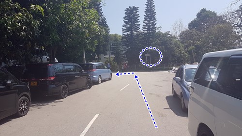
The minibus stop is about 100m in (no signs though, but a bunch of chairs)

Wednesday, January 8, 2014

Wilson Trail Section 8-9-10 (Cloudy Hill, 九龍坑山, Pat Sin Leng, 八仙嶺, The 8 immortals)

(Updated 2020-02-23)
Duration: 
(23.4 kilometers) 8.5 hours

Difficulty: 9/10. For distance and elevation gain.
A shorter and more popular version of the Pat Sing Leng hike can be found here:

http://www.hongkonghikes.com/2020/02/pat-sin-leng-8-immortals.html

Appreciation: 10/10 on a non-smoggy day (was smoggy when I went). You'll also have a bonus view of the large statue of Guan Yin, the Goddess of Mercy. Get some background on the 8 immortals before going: http://en.wikipedia.org/wiki/Pat_Sin_Leng

Cel phone coverage: Partial.

Water needs: 3 liters. 50% shaded

Exercise Area: No

Transportation: Tai Wo MTR station, exit A or B will do. Return via green minibus 55k to Sheung Shui MTR, or 78k bus to Fanling MTR.

Why it's worth it:


Garmin: http://connect.garmin.com/activity/424923922


---------------------------------------
Strictly speaking, my route doesn't start at the beginning of Section 8 but it doesn't require taking the minibus or cab there. And it also skips a less appealing city walk. Follow the map above for the first 2k as there is virtually no signage.

Walk on Po Nga road by the MTR track. That's the road you'll be on when exiting at A or B.

Then, just before the large road crossing, there's a small road to the left, take it and go by the estate.

You'll arrive at a water catchment "river", head right and under the overpass.

Follow the "river" for about 100 meters. Then head right to the road, right before the river turns to the left.

Follow the sign towards Cloudy Hill (Wilson Trail)

Big apartment buildings will be on your left.

You will be back on Po Nga road. Take the pedestrian tunnel under the MTR track.

Right after the tunnel, head right.


You are now on the non-urban portion of the trail. Smooth sailing from this point on.
Just a word of caution as there are many trails branching out from the Wilson trail; at any intersection, look for the little hiking guy (left pic) and follow the arrows. There are also yellow signs from time to time; stay on the Wilson trail. And, as always, there are mileage posts every 500meters. If you stop seeing them, you went the wrong way! They will go upward from W098 to W137. Quite easy.

Getting in to the Pat Sin Leng country park!


As usual, follow the little hiking guy!

You'll be going over the dam.


Good spot for a lunch break, you're about halfway into the hike.


This one was a little bit confusing but you'll see a mileage post soon after.

Haunted?

Going towards Nam Chung. You can relay on my Garmin map at that point.
You will go through a little village towards the end of the trail.

Almost done. Turn left towards the main road to Fanling. There, head left to the bus stop where you can return to the MTR via bus 78k or green mini-bus 55k.

Hike Hong Kong Web Site

HikeHongKOng on Facebook

Please, don't litter!

Hiking is about communion with nature. So please pickup after yourself. There's no excuse to leave plastic bags, water bottles or any rubbish on or around the trails; if you managed to bring it, you can manage to bring it back!