Duration: 5.5 km (2h)
Difficulty: 7/10. 254m elevation gain. But slippery on the way back down.
Cel phone coverage: Everywhere
Water needs: 0.75 liters. 70% shaded.
Appreciation: 7/10 for the Disney fans.
Exercise Area: No
Transportation: Sunny Bay MTR there and back.
----------------------------------------------
Duration:
2 hours (7 km)
Difficulty: 2/10
Cel phone coverage: Everywhere
Water needs: 1 liter
Appreciation: 7/10. There are not a lot of viewpoints but the ones that are there are unusual. And the trail itself is easily accessible, short, and mostly shaded. So that's a nice and easy summer trail for a Saturday morning, or, right at sunset, the main view would be quite spectacular.
Transportation: Take minibus 24M from Admiralty MTR exit A, get off at the terminus at the Mount Butler Estate. Return via Taikoo MTR.
Why it's worth it:
-----------------------
 |
| Admiralty MTR station, exit A |
 |
| The minibus stop is right off the exit, on your left. 24M. Ride should be about 15 minutes |
 |
| You will be dropped off here at the terminus. Get out of the estate and head right on Mount Butler Road. |
 |
| About 200m on Mt Buttler road, you'll be heading left at the junction. Still on Mt Buttler Road |
 |
| Mount Buttler Road sort of merges into Sir Cecil's Ride. Go straight |
 |
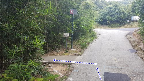
| After about 500m on Sir Cecil's ride, there will be a path on the left, just before the road curves on the right. There's a little sign with Chinese lettering. Take that path on the left. |
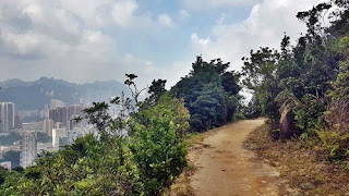 |
| Vistas will open up on your left |
 |
| After about 1 kilometer on Sir Cecil, you'll reach this point (the little loop at marker 2.62km on the map). Go on the bushwack path on the left first to get to the peak and have the nice view. Then retrace your steps to come back to this fork, don't climb the stairs but instead continue on the path (right on the picture above) |
 |
Nice view. Would be even nicer on a clear day, or night.
Unfortunately, lots of morons left their rubbish there
|
 |
This is despicable and by extension, IF YOU left your litter there, YOU ARE freakin' despicable!
There are no valid excuses! You brought it with you, bring it back and dispose it in a trashcan somewhere. I hope I would like to believe that no-one reading my blog would do this. But you can help in telling anyone you catch leaving trash behind that they have to pick it up. Sorry, done ranting now, but it makes my blood boiling that some idiots would think that they can make beautiful pictures but completely trash the environment in which they take these pictures
|
 |
| Follow Dan's directions, he knows his stuff! (Yeah right...) |
 |
Then, pretty straightforward, just keep going on
Sir Cecil's trail
|
 |
| Follow the map instructions, you'll eventually merge into the Quarry Bay Jogging Trail |
 |
Then follow your lovely hosts Dan and May's directions towards Mount Parker's Road.
|
 |
| Little shrine |
 |
| Straight thru at the shrine, don't go right |
 |
| There you go, Mount Parker road! Head left. You will come by a building, The Woodside, which has a small but nice exhibit on Hong Kong's fauna. Worth spending 20 minutes there. They keep going on Mount Parker road until you hit King's road in Taikoo, go right and the Taikoo MTR will be about a 200m walk on King's road. |
Duration/所需時間:
3 hours (9 km return)
3小時(9公里來回)
Difficulty/難度: 1/10
Cel phone coverage/手機覆蓋: Everywhere/無處不在
Water needs/建議帶水: 1 liter / 1升
Appreciation/欣賞: 7.5/10. A lighthouse, caves, the ocean breeze, and a whale's bones (fake but hey, who cares), what else do you need?
燈塔,洞穴,海風和鯨魚的骨頭(假的,嘿,但誰在乎)!
Transportation/交通: Bus #9 from Shau Kei Wan MTR and back. Get off a Cape D'Aguilar Road.
從筲箕灣地鐵坐9號巴士往返。在鶴咀道下車
Why it's worth it/去看看吧:
-----------------------
 |
Take the MTR to Shau Kei Wan (Hong Kong Island line), exit at A3.
The find boarding station 'J' where you will take bus #9. It gets quite busy on weekends as it is the same bus that will take you to the beginning of Dragon's Back.
乘坐地鐵到筲箕灣(港島線),A3出口。
找到登巴士站'J',坐9號巴士。 在周末會很多人,因為這巴士也是去龍脊的。
|
 |
Get off at Cape D'Aguilar Road (鶴咀道).Then just follow Capre D'Aguilar.
A bit boring until you get to the end but really easy.
在鶴咀道(Cape D'Aguilar Road)下車,然後一路隨鶴咀道走。
有點悶,但真的很容易。
|
 |
About 1.5km in, you'll get to the only major intersection.
Do not turn left, stay on Cape D'Aguilar Road (straight).
Afterwards, there will be some smaller paths going off, just stay on the same road
大約1.5公里,你會到達唯一的主要十字路口。
不要左轉,留在鶴咀道(向前是)。
之後,會有一些較小的分支路徑,但你留在鶴咀道便可。
|
 |
Keep going straight at the village's mailboxes
見到村民的郵箱, 繼續直行 |
 |
Another few hundred meters and you'll see the radio towers at a distance
再行多幾百米,你會看到無線電塔在遠處 |
 |
The you will reach the HKT H.F. Radio Station. You won't be able to stay on the road.
Just bypass on the left, as instructed above
然後你將到達鶴咀高頻無線電發射站。 你將無法留在路上。
按照上面的說明,繞過左邊
|
 |
After the fence, just get back on the road that went through the radio station's grounds.
Don't climb the path to the hill.
在圍欄後,走回到通過發射站的路上。
不要爬上山的路
|
 |
Little bit further down Cape D'Aguilar road, you'll reach this fork. On the right is the way to the Institute of Marine Science and the whale's bones. But we decided to go to the lighthouse first, on the left.
在鶴咀道再走一點,你會到達這個分叉路。 在右邊是通往海洋科學研究所和鯨魚的骨頭。 但是我們決定先往左是去燈塔 |
 |
After about 150m, you'll see a few houses and a path to the right. Take it and the lighthouse will be in sight.
There will be a set of stairs on the left.
大約150米後,你會看到一些房子和右邊的路。向右邊的路走便可見到燈塔。
左邊會有一組樓梯
|
 |
Once you are done taking half a million photos of the lighthouse, trace your steps back to the fork and head towards the Institute of Marine Science (the sign says "Cape D'Aguilar Marine Reserve")
當你的相機食飽了五十萬張燈塔的照片後,原路走回到海洋科學研究所(標誌說“鶴咀海岸保護區”) |
 |
Before long, you will see the white building of the Swire Institute of Marine Science at a distance, and the island of Kau Pei Chau on the right.
不久之後,在遠處你會看到香港大學太古海洋科學研究所所的白色建築,右邊是狗髀洲 |
 |
Just before you arrive to the building (about 150m), you'll see an opening on the left.
That's the "secret" path to the cave. A little bit dirty but an interesting rock formation.
就在抵達大樓(約150米)之前,路上在左邊有一條小徑。
這是往洞穴的“秘密”之路。 有點骯髒,但岩層頗有趣的
|
 |
The cave. Once you are done, retrace your steps and head to the white building of the Institute of Marine Science.
山洞。看完後,走回頭路,前往白色的海洋科學研究所 |
 |
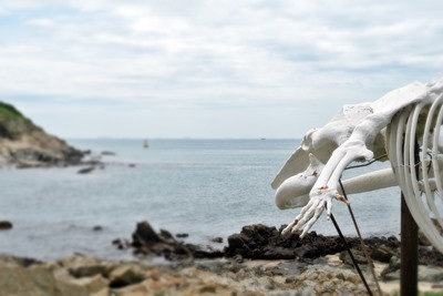
The bones of Miss Willy (海威骨架), in front of the institute.
海洋公園明星殺人鯨海威的骨架模型 |
 |
Explore the surroundings.
周圍探索下吧 |
 |
Another cave, underneath the rock pile. Once you are done enjoying the sights, retrace your steps to the bug stop.
Take #9 back to Shau Kei Wan.
另一個洞穴在岩堆下面。享受完景點,走回頭路到9號巴士站回筲箕灣
|
Please, don't litter!
Hiking is about communion with nature. So please pickup after yourself. There's no excuse to leave plastic bags, water bottles or any rubbish on or around the trails; if you managed to bring it, you can manage to bring it back!