Tin Shui Wai to Tuen Mun via Yuen Tau Shan (圓頭山), the narrow ridge (一線脊), and Castle Peak (青山)
Duration: 15.5km (7h-8h)
Difficulty: 8/10. 893m elevation gain. Very slippery on the downs. Rope assistance on some of the ups.
Water needs: 2.5 liter. Not shaded.
Exercise Area: No
Transportation: Tai Shui Wai MTR exit 'B'. Return via Tuen Mun MTR exit 'B'.
--------------------------
 |
| Tin Shui Wai, exit 'B'. |
 |
| Cross over Ping Ha road via the pedestrian overpass, then head down left. |
 |
| Follow Ping Ha road... |
 |
| ... all the way... |
 |
| ...until... |
 |
... you pass the Sinopec gas station on your left and you arrive at Tin Ha road (that's about 800m from the MTR).
Take a left onto Tin Ha road. |
 |
About 500m into Tin Ha road, you will see Ha Tsuen road on your right.
Turn right into Ha Tsuen road. |
 |
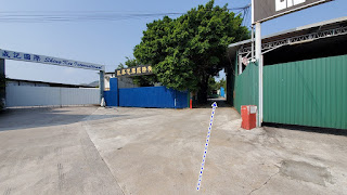
Then keep an eye out for this gate on your left, about 150m into Ha Tsuen road.
You will want to get in between the buildings into that private, unnamed road. |
 |
Just keep going straight until you reach the Kong Sham Western highway (elevated).
Take a right... |
 |
| ... then almost immediately a left. |
 |
| And then another right towards the mountains. |
 |
After 10 minutes walk or so, you will reach the Ling To Tsz temple.
Nice inside. |
 |
| The path going up the hill is down the steps on the right of the temple, then immediately left. |
 |
| There ya go... |
 |
Then, after about 400m on the trail proper, you will reach this point.
Head right into the path which ascends the smallish hill. |
 |
| Junction is under the pylon. |
 |
| Head left under the pylon. |
 |
At this point, it is quite simple; you see the tallest mountain in front of you, Yuen Tau shan.
Just follow the path that gets there... |
 |
| ... rope assistance to climb Yuen Tau Shan. |
 |
| After Yuen Tau Shan, you can't go wrong either; aim for the path that is most direct to your final destination, Castle Peak, which is far in the distance (with the spire). |
 |
| 6.75km into the hike; the narrow ridge. It can safely be bypassed if you want to. |
 |
At about 9km into your hike, you will reach this point where there's a fork going to Por Lo Shan on the right, and Castle Peak, on the left. Head left.
If you want to check-out Por Lo Shan (the mini-Grand Canyon), add an hour to your trek. |
 |
| At 9.3km, down the hill. You will reach this spot where you can chose to go to the left and down on the paved road, for an early exit. Or up the hill, on the right, towards Castle Peak. |
 |
| Again here, quite easy; just follow the path that is leading to Castle Peak. |
 |
| Castle Peak! |
 |
Just before the spire, there's a gazebo, and the path to Tuen Mun in on your left.
About 500 steps down. |
 |
| Pavement now. Head right and down. |
 |
| Left on Yeung Tsing road, then right on Hing Choi street. |
 |
| From Hing Choi street, not too hard to get to Tuen Mun MTR (exit B) |
 |
| Turn left at the end of of Hing Choi street. |
 |
Cross Tsing Wun Road at the pedestrian overpass, a few hundred meters out.
Then keep going on Tsing Wun road... |
 |
| ... until you reach Pui To road, turn right into Pui To. |
 |
| Then just keep going until you reach Tuen Mun MTR, exit 'B'. |
Please, don't litter!
Hiking is about communion with nature. So please pickup after yourself. There's no excuse to leave plastic bags, water bottles or any rubbish on or around the trails; if you managed to bring it, you can manage to bring it back!


