Monday, September 14, 2020

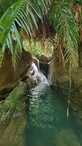
Sha Tin Wai stream - Lower and Mid stream

Duration:  5.5 km (4h). 

Difficulty: 7/10. 243m elevation gain. Lots of big boulders. Do NOT go when the forecast calls for rain as it is likely that this stream gets serious flash floods.

Cel phone coverage: Everywhere

Water needs: 1.5 liters. 95% shaded. 

Appreciation: 9/10. While the stream is a bit dirty, there are lots of waterfalls in the mid-part.

Exercise Area: No

Transportation:  Sha Tin Wai MTR exit D (loop)

Why it's worth it:


Oh, I also saw these guys!

Chinese water dragon


-------------------------------


At Sha Tin Wai MTR, exit via Exit 'D'...

Head left right out of exit 'D', and take the first right, which is going to be Shui Chuen Au Street

Soon enough, you'll see the tall, elevated pedestrian walkway on Shui Chuen Au street


The entrance to the lower part of the stream. That section does not have a lot of waterfalls


The road or path is never more than 5-10 metres out on your left. 
So, you can exit the stream at any point if you are done, or if it starts raining...

This is the end of the lower section of the stream.
Beyond that point is the middle section


That's the end of the middle section. Spot the tree and the waterfall on the left.
That is the only fork in the stream. Exit on the left.

You will arrive right by this picnic/BBQ area


Retrace your steps but on the trail this time, all the way back down to Sha Tin Wai...


Sha Tin Wai to Choi Hung via Tate's Cairn, Elephant Hill (象山), and Kowloon Peak

Duration: 12.6 km (5h). 

Difficulty: 7/10. 689m elevation gain

Cel phone coverage: Everywhere

Water needs: 2 liters. 40% shaded. 

Appreciation: 9/10. 

Exercise Area: No

Transportation:  Sha Tin Wai MTR exit D. Return via Choi Hung MTR

Why it's worth it:


---------------------------------


At Sha Tin Wai MTR, exit via Exit 'D'...

Head left right out of exit 'D', and take the first right, which is going to be Shui Chuen Au Street

Soon enough, you'll see the tall, elevated pedestrian walkway on Shui Chuen Au street

Keep left at this intersection (about 10 minutes from Exit 'D')

Then, just around the corner, head right and onto the road that goes by the large housing estates (on the left on the picture above)

This stretch of paved road is about 400m long.
You will hear the soothing burble of the stream on your right...

Then you will get on the trail proper

The stream will be audible on your right, all the way to the picnic site.

At one point, you'll reach a fork. Take a left and up the steps. The path going down on the right goes to the stream, should you decide to go a dip your toes...

About 40-50 minutes into your hike, you'll reach a bridge with this waterfall on your left, and you will then go through the picnic site.

Go straight...


About an hour in and 2.7km from Exit 'D', you will reach this point where the trail meets the paved road at Shatin Pass. Head left.

There's a little convenience store on the left in the distance.

Head left right after the convenience store (Shatin Pass road)


At about 4km from Exit 'D' and 1.5hour, you'll reach this fork with Kwun Ping road on the left.
Take a right, continuing on Shatin Pass road.

Another 500m and you will get to this fork where you will see a pavilion.
Head left onto Fei Gno Shan road.

The Tate's Cairn observatory will soon be in sight

Juse a couple hundred meters after, you will see the road to Tate's Cairn's observatory on the left. Take it.

Climb up the stairs

Enjoy the glorious views! Once you are done, retrace your steps to the main road and head left for another few hundred meters...

You will reach the Kowloon Peak viewpoint. There's another pavilion there. 

Go past the pavilion and head right to the path as shown in the picture above
(not the stairs up)

Left at the bushy fork


You will reach the Elephant Hill summit, there's just one path, you cannot get lost...

Kowloon peak in sight!

At this point, you will head left and all the way down Kowloon Peak. You will get through the cemetery just before you hit the road. At the road, head right. You will keep taking all the paths that are both going straight and down.


Choi Hung MTR is about 3.3km from the cemetery...

Hike Hong Kong Web Site

HikeHongKOng on Facebook

Please, don't litter!

Hiking is about communion with nature. So please pickup after yourself. There's no excuse to leave plastic bags, water bottles or any rubbish on or around the trails; if you managed to bring it, you can manage to bring it back!