Sunday, February 24, 2013

Mui Wo to Sunny Bay


Appreciation: 9/10. Very scenic. Lots of up and down and no shades so, probably not the best for mid-summer. 

Why it's worth it: 


Duration: 
15k
800m elevation gain 
Total: 4 hours 30 min

Garmin GPS route: http://connect.garmin.com/activity/276881713

Difficulty: 
7.5/10. Slippery at places. Bushwacking at times; trail might not be visible at all.

Cel phone coverage: Partial.

Water needs: 2 liters.

Transportation: Ferry to Mui Wo (Pier 6 in Central). Sunny Bay MTR to return.

--------------------
Off the Mui Wo ferry, head right, following the water.


Get to Silvermine beach
Towards Silvermine falls

About at Silvermine falls
Right at the modern gazebo.

Again right

You will get the trail markers for a while

At this point, is pretty much a single trail. Can't get lost.

Going by Discovery Bay
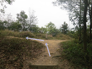
Intersection, go straight. Off the beaten path.
Disco Bay again, in the back.

Bushwacking. The path was still very obvious though. Rely on the Garmin map if it isn't.


About 3 or so hours in. Full-view of the land of Mickey.


Sunny Bay MTR in sight. Be careful on the way down.


Turn left, towards the uninhabited building


Right of it...

... through the gates.

Here, 2 options, if you head right, there's a tunnel underneath the highway. Head left (that's the path we took), you'll have to cross one section of the highway (just a one-way and there's not a lot of cars)

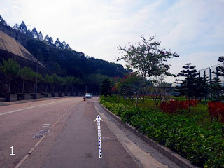
Green path on the right, blue path on the left. They merge on Sunny Bay road. Then do the little loop, under the  Noth Lantau highway, on you are there at Sunny Bay MTR.

Saturday, February 23, 2013

Tsing Yi Waterfront Promenade then Tsing Yi Nature trail


Appreciation: 8/10. Scenic. An easy, short hike that's quite easy to access.

Why it's worth it: 


Duration: 
6.15k
345m elevation gain 
Total: 2 hours 10 min

Garmin GPS route: http://connect.garmin.com/activity/276499006

Difficulty: 
4/10.

Cel phone coverage: Coverage everywhere.

Water needs: 1 liter.

Transportation: MTR Tsing Yi (Exit A2. Go through the mall. Go one level down). Tons of buses and 2 mini-buses will return you to Tsing Yi close to the end of the trail.

--------------------
Refer to the numbered photos for reference to this map
Exit A2 at Tsing Yi MTR. That's leads you into the mall. Go through and go down one level. The mall exits right to the promenade. Head left.

Right after the Tsing Yi Northeast park. Just follow the Tam Kon Shan road for a little while. 

Be on the lookout after the public toilet on the right for the sign for Tsing Yi Nature trail that will be on the left. Head left.

The sign. There will be a bunch of steps. Not that many really.

The the tunnel that gets you under the highway.

Then right after, the paths split. Take the stairs.


About 10 minutes walk or so later, you'll reach the minibus bus terminal. Take the stairs on the right and head right on Lio To road. The road will curve to the left after about 200 meters.

End of pavement and Lio To. From that point on, it's all trails.
Head right.
Head right.

The path is new and quite nice. You'll go past a few gazebos and swings.
At this point, if you head left, that's the short way back to the North Entrance of the trail, where you came from. You want to head right towards the South Entrance.


Nice views of the bridge. Supposed to be really nice at sunset.


End of the trail proper. If you head left and walk and extra 150 meters, you'll reach the bus stop. Various buses will take you back to Tsing Yi. The two minibuses are probably your best option.


Sunday, February 17, 2013

Lam Tin to Po Lam via Little Hawaii trail


Appreciation: 4/10. Not very scenic. Lots of walking on paved roads. Not all that well signed. Not the most interesting hike. But still, if you live in Tseung Kwan O, can be good exercise.

Why it's worth it: 


Duration: 
7.14k
301m elevation gain 
Total: 2 hours

Garmin GPS route: http://connect.garmin.com/activity/274220271

Difficulty: 
5/10.

Cel phone coverage: Coverage everywhere.

Water needs: 0.5 liter.

Transportation: MTR to Lam Tin (Exit A). Return by Po Lam MTR.

--------------------


Exit 'A' at Lam Tin MTR station.


Climb up the stairs to cross the street.

You can go under the building or through the mall.

Take Ping Tin street.

Left on On Tin Street.

Cross On Tin street when you arrive at Tak Tin street. 

Climb the stairs towards Lam Tin park.


Lam Tin park. Climb more stairs.


Yet more stairs.
Head left.

Left again.


Take the path on your right leading to...
... yet more steps!

You will reach Wilson trail section 3. Head left.


Wilson trail marker.


About 2.2 km in, you'll reach this junction point. Head down left (don't take the stairs up).

After the folks art, you'll reach the end of the path. Head right.

You'll get into a village where directions gets a bit confusing. Make sure to follow the Garmin map closely.

You'll know you are at the right path when you spot the Wilson Trail sign markers.

Keep going on Ma Yau Tong road which becomes Tsui Lam Road eventually. Go to the end of it (past the gate), until the car pavement ends. Take the stairs on the left.


A few hundreds of meters later, you'll reach a cross-path with a  Little Hawaii trail sign on your right, going down. Take it.


You'll eventually go by the small waterfall on your left. You're not very far from the end at this point.

At this juncture, go straight to go to the endpoint which is Tseung Kwan O. However, if you have some time, head right until you reach the second waterfall.

That's the second waterfall. Quite nice. Retrace your step to the TKO junction.

You'll get to Tseung Kwan O. Keep walking and you'll see the MTR signage.

Hike Hong Kong Web Site

HikeHongKOng on Facebook

Please, don't litter!

Hiking is about communion with nature. So please pickup after yourself. There's no excuse to leave plastic bags, water bottles or any rubbish on or around the trails; if you managed to bring it, you can manage to bring it back!