Showing posts with label 11km. Show all posts

Sunday, October 28, 2018

Wong Nai Chung Reservoir to Sai Wan Ho via Tai Tam and Boa Vista (野豬徑)

Duration: 
11km total. 3.5 hours

Difficulty: 
5/10. 2/3 of the hike is on concrete paths. Not a lot of elevation gain (375m over 11km)

Cel phone coverage: Everywhere.

Water needs: 1.5 liter.

Appreciation: 7/10. Easy access. Some nice views but a lot of concrete.


Exercise Area: No.

Transportation: Bus 6, 63, 66, 76, minibus 5, get off at Wong Nai Chung Reservoir. Return via Sai Wan Ho MTR.

Why it's worth it: 

------------------------

Get off at the Wong Nai Chung Reservoir stop (gas station).
Climb the stairs and head left...

...going towards Hong Kong Parkview

You see the Hong Kong Parkview buildings in the distance


Keep on left at the Hong Kong Parkview estate


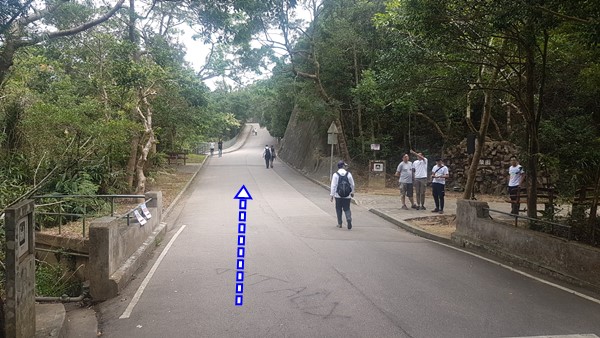
You will basically be following the main asphalt path all the way to Tai Tam reservoirs 

Tai Tam reservoir, about 30-40 minutes into your hike.

Take the bridge over a branch of Tai Tam reservoir.

Head right (although heading left gets you to the same place and may be a tad faster)

Head left at the next bridge

Go over the main dam


Then head left at the end of the dam. You are now on Mount Parker Road

You'll reach this fork about 5 minutes later, head right, leaving Mount Parker Road and onto The Hong Kong Forest Track-Boa Vista Track Section.


About 20-25 minutes after having forked-out of Mount Parker Road, you'll reach this point where the road makes a big U. Boa Vista is at the bottom of this U. But, as shown on the map, we skipped it and instead took the shortcut which is shown on the picture above. However, this completely skips Boa Vista so, keep going if you meant to see it.

If you don't take the shortcut because you want to see Boa Vista, keep going along the road for about 5 minutes until you reach the bottom of the 'U' in the road. You will see stairs going down on the right of the road. If you take them, you'll get to Boa Vista. Enjoy and retrace your steps to the road when you are done. Then keep going.

After about another 5-7 minutes, you will reach this point. Follow the path next to the catch-water.

Stay on the main path, don't take the stairs going up.

About an hour to 90 minutes walk after you have left the 'U' in the road, you'll reach this fork. Take a right.


Right

Back to civilization. The road going down is at the end of the park and to the right.

Go all the way down to Yiu Hing Road. Then head left on Yiu Hing Rd

Keep going on Yiu Hing Rd...

Until you reach Shing On Street, then turn right onto it...

Sai Wan Ho MTR station is just a couple of minutes away.


Monday, May 26, 2014

Tai Tam to Quarry Bay via Sheung Tam Stream (雙潭石澗)

(updated 2022-03-11)
Duration: 
(11 kilometers)
4.5 hours

Difficulty: 7/10. 592m elevation gain

Cel phone coverage: Everywhere.

Water needs: 1.5 liter

Appreciation: 9/10. Great stream after a downpour, and great views of Victoria Harbour

Transportation: Sai Wan Ho MTR, Exit A. Take bus 14 and exit right after the dam. Return via Quarry Bay MTR.

Why it's worth it:


Map & Details: 

Exercise Area: No

---------------------------------------
The bus stop to Tai Tam is right off Sai Wan Ho MTR, Exit A. About 25 minutes ride.
Ring the bell when you're on the Tai Tam dam (there's just one on the way). Stop right after the dam.

Beginning of the trek is right across the bus stop.  

It starts with a nice and gentle paved hike.

Head left right before the bridge.

Then right and down.

You'll go by this dam. There's a path going up on the other side of the walkway.

About 20m into that path, it curves to the left. Take the offshoot path to the right and get into the stream. 

Lots of places to swim if you feel like it on a warm day.

This first stream ends about 100m before the dam. There's a picnic area on the right on an elevated stone area.

After a short break (maybe a snack). Head left on the path.


Left after the dam's bridge

Follow Wong Nai Chung Gap Road

At this point, head right and down. You are going towards the second stream

Don't enter the stream on the first waterfall on the left. The stream to enter is about 10-15 minutes walk further along the path.

That's the stream you will enter, at the end of the footpath. Just don't enter it right away a go up behind the sign and you'll see the entry point to the stream a few meters up.
There's one big waterfall and a few nice pools.

This is the end of the second stream. Go up the stairs and onto the road.

You'll see the ParkView estate on your right. Walk towards it.

Then, back on a bone fide trail. On your right, you can't miss the entry point to the Wilson Trail.
That's where you are going. 


Whenever there's an intersection, keep following the Wilson trail signs

Follow this little guy

At one point, you'll reach somewhat of an open-air temple. At this point, just go straight, you no-longer are following the WIlson trail. From this point on, just keep going towards the city. You can't really get lost. Once you reach the town, Quarry Bay MTR is on your left, Tai Koo MTR on your right, pretty much at equal distance.
Hope you liked your hike!

Hike Hong Kong Web Site

HikeHongKOng on Facebook

Please, don't litter!

Hiking is about communion with nature. So please pickup after yourself. There's no excuse to leave plastic bags, water bottles or any rubbish on or around the trails; if you managed to bring it, you can manage to bring it back!