Register and get cash back:
http://amex.com.hk/refer/jEANCCqqi5?CPID=100433829
Why it's worth it:


Duration:
Option 1: Long, hard and a bit scary, less safe. 13 kilometers, 7 hours if you are not stopping/taking a dip.
Option 2: Loop it. Shorter, safe. 3 hours x 2 (for retracing your steps). 6 hours if you are not stopping/ taking a dip.
MTR to stream (dam): 1 hour. 3.5k
Stream: 2 hours. 2.5k. Could way more fun time to laze in the sun, bathe in the pools, lunch.
(Trace back your steps to Tung Chung if you go for Option 2)
Stream to ribbon path past the "climbing part": 20 minutes
Ribbon path to unnamed trail: 1 to 1.5 hour. About 1k. Steep.
Unnamed trail to Lantau trail (L11): 25 minutes. 1k.
Lantau trail (L11) to Mui Wo: 1.5 hours. 5k
MapMyHike: Wong Lung Hang stream
Difficulty: 10/10 for option 1. I rate it an 10 because there's a few places where you rely strictly on a rope to climb a cliff. Some light rock climbing. Not for the entry level hiker. Consider not attempting the climb at the end if you have any doubt about your abilities. You can instead retrace your steps in the stream.
6/10 for option 2; you just avoid all of that rock-climbing and just get back the way you came from.
This cannot be done as a dry trek if you're in the middle of summer and it has rained a lot (ie. you will get wet)
Cel phone coverage: Pretty much everywhere (trail and stream).
Water needs: 2 liters.
Appreciation: 10/10. Amazing waterfalls. The water is very clear and inviting. High density of waterfalls after a good week of rain.
Transportation: Take the Tung Chung (東涌) line MTR to Tung Chung (about 40 minutes from Hong Kong Station). If you do option 2, you'll loop back to Tung Chung. For option 1, you will take the ferry from Mui Wo back to Central.
-----------------


 |
| Tung Chung MTR, exit 'A'. |
 |
| #1. Walk towards the big ugly concrete buildings. |
 |
| #2. Follow the path which parallels Tat Tung Road road, then follow that path to the left, paralleling ShunTung road. |
 |
| #3. At the pedestrian/bicycle tunnel, head into it. |
 |
| Straight or left will do. |
 |
| #4. You will now follow Yu Tung road and take the first overpass. |
 |
| #5. Turn left in the middle of the overpass, towards "Tung Chung Fort" as the sign indicates. |
 |
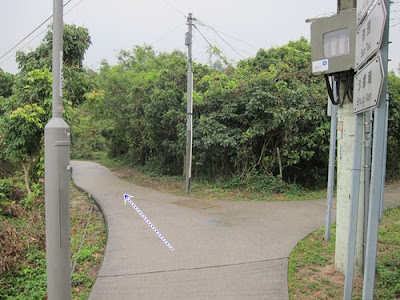
| #6. Head right at the road. |
 |
| #7. Then left into Wong Lung Hang road. |

 |
| Tei Po New Village, just go through. |
 |
| Keep going... You will see a bunch of openings to the Wong Lung Hang stream on your left at times. It is too early to go in. |
 |
| Keep going. |
 |
| Keep going. With the waterfalls at a distance, you feel like you entered a different world. |
 |
| #8. Small bridge, keep going... |
 |
| Picnic site? Keep going... |
 |
| #9. Aaah, Wong Lung Hang trail. Must be it? Nope, keep going on the road. Simple; you keep going on the road until it ends. |
 |
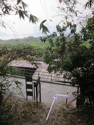
| #10. Finally, it does end. There's a water contraption on the right with a tunnel an a vehicle ramp. You want to go left on the slope down to the stream. That's where the stream trek starts. |
 |
| Right into the stream, you will see a dam on the right and one on the left. Go right. |
 |
| Climb the dam, then the ladder to bypass the water pool. Unless you want to swim across. |


 |
| Distinctive rock with Chinese markings. Almost washed away though. |
 |
| There are a few smaller streams merging into Wong Lung Hang but you must stay on the main stream. |
 |
| Wong Lung waterfall. 2 hours into the trek, 1 hour into the stream. Really nice pool. The waterfall can be bypassed on the left. Big rock steps make it relatively easy. |

 |
| The water is so clear. Feel free to stop for a dip at any time. |

 |
| You arrive at the Three-Dragon Gap where the left dragon waterfall awaits (left on the pic), about 2 hours into the stream, 3 hours from the MTR station. A little bit further, you'll see the right dragon (as expected, on the right on the pic) and the gorge ends with the dragon tail waterfall. This gorge has very much a Lord of the Rings' Rivendell feel to it. |
 |
| Left dragon. No worries, you are not to climb this one. |
 |
| Ok.At this point, the choice is yours; if you want to keep moving on towards Mui Wo, climb up the left-side of the stream (there should be some ribbons-if not, check the picture and you should be able to figure it out relative to the rocks). Word of warning, this way is low-level rock-climbing and there is no way back in the middle. Some ropes are there for assistance in the more tricky portions but you are basically putting your safety in the hands of some stranger. The path is also only ribbon delimited so, there are risks you may feel or get lost (although the rule is, keep going up and you'll eventually hit a trail) . Please note that I added my own blue ribbons on 2014-04-12 and they are much easier to track as each ribbon is within sight of another. That blue ribbon path will get you to the top of the mountain. If you don't feel comfortable with any of the above, you can just go back the way you came (Option 2) and you won't have missed anything (there are no waterfalls beyond this point). |
 |
| Sheer cliff with a rope. I'd suggest you lower the risks and instead follow the ribbons on the left . There's some climbing but nothing like that cliff. |
 |
| Some unavoidable rope climbing a little bit further up. It's just a few meters but I don't like the idea of relying on strangers for my safety. That one is the last bit of "rock climbing" required. |
 |
| Keep going up |
 |
| After the last pitch, you are done "rock-climbing". But there's still a steep ascent which is strenuous due to the fact that there isn't really a path. Be careful to follow the ribbons (mine are blue) or you will get lost. In any case, just keep climbing towards the peak. You will be in the bushes/forest for 90% of the way up but once it clears out, you are not too far from the top. |
 |
| Once at the top. There're somewhat of a path which may or may not be overgrown. In any case, there will be a stream on your right. Keep walking straight from where you came, parallel to the stream. There will no longer be ribbons. You'll eventually reach a proper path. Head right. |
 |
| About 15-20 minutes minutes in, you will reach the Lantau trail at milestone L011. Head left towards Mui Wo via Nam Shan. From here, it's about 8k of downhill hike. Stay careful about the steps if it rains because they can be slippery. |
 |
| Pui O at a distance. |
 |
| Final destination, Mui Wo. The trail ends close to the bus terminus and ferry. You can Ferry back to Central. Wasn't that a magical hike? |


