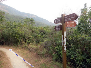
Appreciation: 7/10. An easy hike that is short and shaded. Perfect for a slow afternoon. A forest hike so no much in terms of views. Some WWII remnants and quite a few cats towards the end.
Why it's worth it:
6.5k
285m elevation gain
Total: 2 hours
Garmin GPS route: http://connect.garmin.com/activity/266067566
Difficulty:
285m elevation gain
Total: 2 hours
Garmin GPS route: http://connect.garmin.com/activity/266067566
Difficulty:
5/10.
Cel phone coverage: Coverage everywhere.
Water needs: 0.5 liter.
Transportation: Take NWFB #15 from Exchange Square and get off at Wan Chai gap road. Return to Causeway Bay via CityBus #76 (will stop close to TimeSquare where you can take the Causeway Bay MTR).
--------------------
 |
| Off the bus at Wan Chai gap. Walk towards the little park and gazebo. Take the road immediately to the left of the park (Mount Cameron Road) |
 |
| 100m into Mount Cameron Road, you will see the intersection to Aberdeen Reservoir Road and the trail sign. Head right onto Aberdeen Reservoir Road |
 |
| The WWII bunker in question. |
 |
| Keep going on Lady Clementi's Ride for a few more minutes and you'll reach Hong Kong Trail Section 4. Head left. |
 |
| You are on the right path... |
 |
| Just keep following the little hiker guys on the sign, towards Black Link's |
 |
| About 1 hour into the hike |
 |
| Some of the rare views |
 |
| At Black Link's road, hit right. |
 |
| Be on the lookout for the mighty little felines on either sides of the road. |
 |
| There you go; end of Section 4, start of Section 5. The bus stop is just around the corner (where the car is going on the picture) |


