Sunday, December 30, 2012

Lantau Trail Section 1 & 2

Appreciation: 8/10 overall. Section 1 is pure waste of time but about 1 hour in (4km) and into Section 2, great vistas are well worth the climb.

Why it's worth it: 


Duration: 
8.15k
827m elevation gain
Total: 3 hours

Garmin GPS route: https://connect.garmin.com/modern/activity/255733934

Difficulty: 
7/10.

Cel phone coverage: Coverage everywhere.

Water needs: 1 liter.

Transportation: Ferry to Mui Wo from Central pier. Return via 11, 23, 3M right at the end of section 2 to either Tung Chung where you can take the MTR, or Mui Wo where you can ferry back. 

--------------------
Head right upon disambarking the Mui Wo ferry.

Start climbing along the road by the roundabout.

You will see this sign. Follow it for until you reach the Section 2 trail head.

Section 2 trail head. There's a drink vending machine and toilet in case you forgot.

The rest is trivial. No real need for further details as all the intersections have clear indications. Just follow Pak Kung Au via Sunset Peak

Sunday, November 25, 2012

Lung Fu Shan Country Park; Pinewood Battery

Appreciation: 7/10 for the historical background on the site. Note much hiking, views are mostly at The Peak. Hong Kong birds of prey flying around from time to time are nice to watch.
For more info on the PineWood Battery: http://en.wikipedia.org/wiki/Pinewood_Battery

Why it's worth it: 


Duration: 
3.5k
30m elevation gain
Total: 1 1/4 hour

Garmin GPS route: http://connect.garmin.com/activity/246176688

Difficulty: 
3/10.

Cel phone coverage: Coverage everywhere.

Water needs: 0.25 liter.

Transportation: From Exchange Square bus terminal in Central, take bus #15 to The Peak. At the end of the trail, there quite a few minibuses/buses which will take you wherever you want to go.

--------------------
Once you arrive at The Peak, You take Harlech road, which will be on your left if you face the Peak building with tram tracks on your right. Harlech road is the first part of the Peak loop trail.


On the Peak loop trail, quite peaceful.

After a 20 minutes walk (about 1k), you will branch out of the Peak loop and into Hatton Road


You'll see a sign for the Lung Fu Shan Contry Park on your  left.

Just a few steps and you'll be at the Pinewood battery.

There are quite a few information placards so no need to give you the history of the battery here, it's well documented on site, and online.

Imagine with the big gun.

Once you are done, keep on Hatton road towards the University. There are various paths to get to bus stops. Follow my Garmin map to step in our tracks, or you can also exit earlier.

Hong Kong U.

Saturday, November 17, 2012

Hong Kong trail Section 8: Dragon's back (龍脊)

Get your AMEX Cathay, access airport lounges for free, and get 80,000 Asiamiles
http://amex.com.hk/refer/jcclemjb01?XLINK=MYCP


Appreciation
/欣賞: 8.5/10 for the first kilometer, the rest is not all that interesting. 

Why it's worth it: 


Duration/所需時間: 
7.5k
高度差異: 230m elevation gain
Total: 2 hours + 30 min if you walk from Big Wave bay (Tai Long Wan) to Shek-O. 2小時.  如由大浪灣行到石澳: 30分鐘

Garmin GPS route: http://connect.garmin.com/activity/244022876

Difficulty/難度: 5/10

Cel phone coverage/手機覆蓋範圍: Coverage everywhere. 全程

Water needs/需水量: 1 liter. 1

Transportation/交通MTR to Shau Kei Wan, Exit A3. Take NWFB bus #9 towards Shek-O, stop at To Tei Wan on Shek O Road. Return via same NWFB bus #9 in Shek-O which will bring you back to Shau Kei Wan.
地下鐵路至筲箕灣A3出口 乘坐新巴巴士9號線前往石澳在石澳道土地灣下車回程由石澳坐新巴9號巴士返回筲箕灣

--------------------

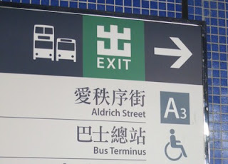
MTR Shau Kei Wan, Exit A3. The bus terminus is right by the exit.
地下鐵筲箕灣A3出口 巴士總站就在出口處

Take #9
#9巴士


Stop at To Tei Wan on Shek O Road. 
在石澳道土地灣下車
The start of Hong Kong trail Section 8 is right by the bus stop.
港島徑第8(龍脊) 的起點 就在巴士站旁邊

From that point, there's really no way to get lost; the path is well signed at every turn (follow the little hikers pictograms).
從這起點真的沒有辦法會迷路的;  路徑在每一個地點也有很明確的標記跟著小登山者的標記行吧

After about 2 hours, you'll arrive at Tai Long Wan beach. You can walk towards Shek-O or take the red minibus that will get you there. From Shek-O, bus #9 will take you back to Shau Kei Wan.
2小時後你便抵達大浪灣海灘 你可以行向石澳或乘坐紅色小巴也可回程由石澳坐新巴9號巴士返回筲箕灣

Monday, September 10, 2012

Chi Ma Wan trail (芝麻灣 Sesame bay)


Appreciation: 8.5/10. Although not as scenic as MacLehose section 2 and 3, Chi Ma Wan has some gorgeous sights. And it starts and ends at a beach so that's quite nice in itself.

Why it's worth it: 


---------------------
Duration: 
18k
269m elevation
Total: 6-7 hours

Garmin GPS route: https://connect.garmin.com/modern/activity/220622142

Difficulty: 
7/10, 8/10 if really hot as the first few kilometers are in plain sun and climbing.

Cel phone coverage: Coverage everywhere.

Water needs: 2 liters.

Transportation: Central Pier 6 to Mui Wo. 35 to 50 minutes depending on whether you take the fast or slow ferry. Then take NLB 1 and stop in Pui-O (about 10 minutes). Return the same way.

--------------------
Exit the bus in Pui-O. That's the first village after the drive in the hills.

At the 'Welcome to Pui O' statue, take the Chi Ma Wan road.

Follow the Chi Ma Wan road.

You will be walking on Chi Ma Wan road for 25-30 minutes.


Eventually, on your right, you will see the start of the Chi Ma Wan country trail for you to take. 

Take the stairs next to the map. Don't take the left nor right path.

About an hour and 3.5km in, you will have reached the Miu Tsai Tun peak.
Soak-in the amazing views. The path path will go down a bit then back up to the Lo Yan Shan peak. After Lo Yan Shan, it's mostly shaded and a relatively easy hike.

About 45 minutes after Miu Tsai Tun, you get to this intersection, head left. There's proper signage.

About 30 minutes later, you'll have reached the Shap Long Irrigation reservoir. At the intersection, head right and cross on the dam. Suggestion if it is really hot: take you t-shirt off, dip it in water, squeeze and put back on. Very refreshing.


1:45 minutes later, you'll reach that crossroads. Head left. 

Just in case you get confused here. Head straight. Stay on Chi Ma Wan country trail.

That is 5 hours from the bus stop. About 16 km into the hike. This is also where you leave the Chi Ma Wan trail which goes and loops back to where you entered it, and instead head left for a nicer walk to the Mong Tung beach and leisurely walk back to Pui-O.


Saturday, August 4, 2012

Lantau Section 12/12


Appreciation: 5/10. There are much nicer trails to be hiked. Lots of gigantic spiders if you're into arachnids. One great view of Pui-O but that's it, the rest is pretty boring.


Why it's worth it: 


---------------------
Duration: 
7.24k
330m elevation
Total: ~2 1/4 hours


Garmin GPS route: http://connect.garmin.com/activity/204234149 


Difficulty: 
4/10. A little bit of uphill but nothing to scare a monkey.

Cel phone coverage: Some coverage on trail.

Water needs: 1 liter.

Transportation: We did it in reverse. Ferry from Central Pier 6 to Mui Wo. 35 to 50 minutes depending on whether you take the fast or slow ferry. At the end of the trail, you can bus back to Mui Wo. NLB 1 or 4.


Head left right out of the ferry, walk by the McDonalds, following the shore. First road on the left.

On that road, there's will be signage for the trail, although they are easy to miss.

After a little while. This was a little bit confusing but head left, don't stay on the road.

Signage is pretty good.


Almost there. If you are not bent of doing the full Lantau trail, I would suggest you skip section 12. The girlie drinks at Pui-O's Oh La La are pretty refreshing however...

Hike Hong Kong Web Site

HikeHongKOng on Facebook

Please, don't litter!

Hiking is about communion with nature. So please pickup after yourself. There's no excuse to leave plastic bags, water bottles or any rubbish on or around the trails; if you managed to bring it, you can manage to bring it back!