Monday, September 10, 2012

Chi Ma Wan trail (芝麻灣 Sesame bay)


Appreciation: 8.5/10. Although not as scenic as MacLehose section 2 and 3, Chi Ma Wan has some gorgeous sights. And it starts and ends at a beach so that's quite nice in itself.

Why it's worth it: 


---------------------
Duration: 
18k
269m elevation
Total: 6-7 hours

Garmin GPS route: https://connect.garmin.com/modern/activity/220622142

Difficulty: 
7/10, 8/10 if really hot as the first few kilometers are in plain sun and climbing.

Cel phone coverage: Coverage everywhere.

Water needs: 2 liters.

Transportation: Central Pier 6 to Mui Wo. 35 to 50 minutes depending on whether you take the fast or slow ferry. Then take NLB 1 and stop in Pui-O (about 10 minutes). Return the same way.

--------------------
Exit the bus in Pui-O. That's the first village after the drive in the hills.

At the 'Welcome to Pui O' statue, take the Chi Ma Wan road.

Follow the Chi Ma Wan road.

You will be walking on Chi Ma Wan road for 25-30 minutes.


Eventually, on your right, you will see the start of the Chi Ma Wan country trail for you to take. 

Take the stairs next to the map. Don't take the left nor right path.

About an hour and 3.5km in, you will have reached the Miu Tsai Tun peak.
Soak-in the amazing views. The path path will go down a bit then back up to the Lo Yan Shan peak. After Lo Yan Shan, it's mostly shaded and a relatively easy hike.

About 45 minutes after Miu Tsai Tun, you get to this intersection, head left. There's proper signage.

About 30 minutes later, you'll have reached the Shap Long Irrigation reservoir. At the intersection, head right and cross on the dam. Suggestion if it is really hot: take you t-shirt off, dip it in water, squeeze and put back on. Very refreshing.


1:45 minutes later, you'll reach that crossroads. Head left. 

Just in case you get confused here. Head straight. Stay on Chi Ma Wan country trail.

That is 5 hours from the bus stop. About 16 km into the hike. This is also where you leave the Chi Ma Wan trail which goes and loops back to where you entered it, and instead head left for a nicer walk to the Mong Tung beach and leisurely walk back to Pui-O.


Saturday, August 4, 2012

Lantau Section 12/12


Appreciation: 5/10. There are much nicer trails to be hiked. Lots of gigantic spiders if you're into arachnids. One great view of Pui-O but that's it, the rest is pretty boring.


Why it's worth it: 


---------------------
Duration: 
7.24k
330m elevation
Total: ~2 1/4 hours


Garmin GPS route: http://connect.garmin.com/activity/204234149 


Difficulty: 
4/10. A little bit of uphill but nothing to scare a monkey.

Cel phone coverage: Some coverage on trail.

Water needs: 1 liter.

Transportation: We did it in reverse. Ferry from Central Pier 6 to Mui Wo. 35 to 50 minutes depending on whether you take the fast or slow ferry. At the end of the trail, you can bus back to Mui Wo. NLB 1 or 4.


Head left right out of the ferry, walk by the McDonalds, following the shore. First road on the left.

On that road, there's will be signage for the trail, although they are easy to miss.

After a little while. This was a little bit confusing but head left, don't stay on the road.

Signage is pretty good.


Almost there. If you are not bent of doing the full Lantau trail, I would suggest you skip section 12. The girlie drinks at Pui-O's Oh La La are pretty refreshing however...

Tuesday, July 24, 2012

Stream trek: Sheung Luk stream 雙鹿石澗 (Double deer)

Appreciation:
 I'll say 8.5/10 because I think Wong Lung Hang is nicer. 


Why it's worth it: 


---------------------
Duration: 
Bus stop to stream: 45 minutes. 2.8k
Stream: 3 hours, ~3k
Hike to bus stop: 1 hour, ~3k
Total: ~5 hours (Do account for 30 minutes shuttle from Sai Kung which is not frequent)


Garmin GPS route: http://connect.garmin.com/activity/201383534 


Difficulty: 
10/10. Some parts of the climbs can't bypassed and are not recommended if you are afraid of heights or out of shape.

Cel phone coverage: Rare coverage on stream. Somecoverage on trail coming back.

Water needs: 2 liters.

Transportation: 

-------------------


Get to the Diamond Hill MTR station.'s bus terminus, or  Choi Hung MTR exit C2. Bus 92 will get you to Sai Kung any day. It is about 1/3 the price of 96R but it is slightly longer (50 minutes instead of 35). On Sundays and holidays, you have the option of taking 96R. Check the PTES schedule for details (http://hketransport.gov.hk).

Once in Saikung, you can either wait to get to the bus terminus or get out one stop before, at the Police Station. Might be good if you intend to beat the hikers crowd to the 29R village bus which has limited seating (28) and frequency. You will want to get to Chan Man street.

On the left, that's the signpost for the 29R, right by the McDonald's (it looks handmade). The bus itself is a little bit larger than a regular mini-bus (pic on the right). If you miss the bus, take a cab and ask them for the Sai Wan Pavilion.
Sai Wan Pavilion - 西灣亭

After about a 20-25 minutes ride, the 29R will drop you off at the Sai Wan Pavilion, right by our trail head. Just follow the trail.

About halfway to Sai Wan, you'll climb a bunch of steps and get to a map point. Go straight.

Arriving at the Sai Wan village. Just go straight through.

At the crossroad, just before the beach, head left. You'll get over a little hill, to another beach

At the end of the beach, there's a stream and a bridge crosses it at a distance. Walk towards the bridge and go past it on the left-hand side. Go through the bushes and you'll see a clearing with mesh fences forming some sort of a pen. Go around it on the right, keep walking parallel to the stream. Eventually, the view will open up to the stream and the mountain.

Map of the stream with references, via HK Adventurers
(1) You will first go by a punch of deep pools. Pass on the left. When it is hot, these are packed with people.

(2) Refered to as "the wall", Thousand Silk Falls (千絲瀑). Looks harder than it really is. Climb on the right. 


(3) Ming Yau Falls (鳴幽瀑), 30ft tall. Path to bypass is on the right.

We're bypassing the falls, ending up on top.

(4) The 100ft tall Chong Yau Falls (藏幽瀑). Climb on the left. Not very difficult  but it is definitely more work than your regular hiking.

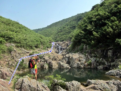
(5) You'll arrive to this gorge with no option but to boulder your way through on the left-hand side. It is a bit tricky.

Black Deer Pool Falls, 45 feet tall. Bypass on the right.

(6) Reindeer Pool (順鹿潭). Climb on the left. Be careful, tricky climb as well.

(7) 60ft-tall Well Bottom Pool(井底潭) Falls which should be bypassed on the right-hand side.

(8) Ben Cho Falls (奔槽瀑). Climb on the left.

Then right after, you reach the exit point. The path on the right is not really obvious but just be on the lookout after the Ben Cho Falls  

You will reach the main trail. Head left. Continue all the way to  Pak Tam road where you can catch the bus back to Sai Kung. A mostly downhill 3k.

Monday, July 9, 2012

Wang Chung stream (橫涌石澗)


(Updated: 2020:JUL-26)
Why it's worth it: 


---------------------
Duration: 
Bus stop to stream (bridge): 8 minutes. 0.4k
Stream: 2-3 hours, ~2k
Hike back to minibus at dam: 25 minutes, 1k
Total: 3-3.5 hours

Map & Details: https://www.mapmyhike.com/workout/4530714139/


Difficulty: 
6/10. Not very hard. Still stream trekking though so it is more challenging than regular hiking. Please, do not attempt to climb directly in the larger falls. People did lose there lives there. Instead, follow the ribbons to bypass the larger falls.

Cel phone coverage: Rare coverage on stream. Full coverage on trail coming back.

Water needs: 1 liter.

Exercise Area: No

Appreciation: 9/10 lower part of the stream, 7/10 higher part; the big falls are in the first half. Need to go once it has rained a lot to get decent water flow however.

Transportation: Go on Sundays, you'll have the luxury of taking KMB bus 275R from the Tai Po MTR station which will drop you off very close to the stream entrance (otherwise, you'll have to walk an extra hour to the stream).  Same way return. Note that the last bus is at 18:45 so don't be too late.

-------------------
Take the East Rail MTR to Tai Po. Exit A3, tunnel, then follow directions leading you to bus stop 275R (it is behind the pillar although the schedule is in front of the pillar).
(1) No choice but to get out as your stop is the terminus station.
Follow the road back towards where your bus came from.


Quite a short walk actually; about 8 minutes to the bridge where you will see the stream on your right.


(2) Take the steps down right by the sign that tells you not to enter... ;-)
You will walk along the stream for a few meters then enter the stream proper.

(3) 15 minutes into the stream, you'll see this first medium size fall. Bypass it on the left .

(4) DragonBall Waterfall(龍珠瀑). One of the most spectacular waterfall I have seen in Hong Kong,  after good amount of rain. Clear bypass on the left, marked with ribbons. Don't try to climb the waterfall.

The bypass. Going back to the top of the waterfall.

Right at the top.

(5) About 20 minutes after the waterfall, you'll reach this dam.
Pass to the left, there's a path to avoid the subsequent pool.

(6) Another 20 minutes and you'll reach this large pool. Although the climb looks easy enough, if you want to do so, you'll have to swim there. Otherwise, bypass it following ribbons.

(7) 15 minutes after, you'll get to the other major falls. Quite pretty when there's good waterflow. Bypass on the right .

(8) 30 minutes or so after, the final set of falls with a wading pool in front.
Although  I didn't think the water was all that clean (there were vegetables in the water at the dam!)

The stream becomes flat, narrow and relatively uninteresting afterwards.
Use the various footpaths on either sides.

(9)  Eventually, a bridge on the Pat Sin Leng Nature Trail (八仙嶺自然教育徑) will be in sight., about 20-25 minutes after the last set of falls. You can't miss it. That's the end of the stream for you.

(9) Head right on the bridge. The path parallels the stream for a short while.
It will take you about 20 minutes to get back to the bus stop.

You'll eventually get to the direction stones, follow on the right towards Bride's Pool.
If it is early enough, go check-out the Bride's Pool's falls. Afterwards, bus 275R will bring you back to Tai Po
(stop is right by the gazebo).

Hike Hong Kong Web Site

HikeHongKOng on Facebook

Please, don't litter!

Hiking is about communion with nature. So please pickup after yourself. There's no excuse to leave plastic bags, water bottles or any rubbish on or around the trails; if you managed to bring it, you can manage to bring it back!