Duration: 15 km (4.5h)
Difficulty: 7/10. 545m elevation gain. Now, part of the trail is overgrown and unclear. There's some risk of getting lost as part of the trail gets less clear towards the middle of it. Better make sure that you start no later than 11am so you do not get lost when night falls.
Cel phone coverage: Everywhere
Water needs: 2 liters. 95% shaded.
Appreciation: 7.5/10. Nice if a bit ordinary.
Exercise Area: No
Transportation: Tsuen Wan MTR, Exit 'A'. Return via any of the many busses available at the end of the trail.
------------------------------
 |
Tsuen Wan, Exit 'A'
|
 |
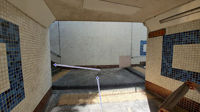
You will be following a pedestrian walkway for about 1km which follows the train track on your right. Go all the way to the end of it.
|
 |
At the end, you will reach that point. go across the plaza and there is going to be an escalator...
|
 |
Go down the escalator, then left. You will be on Mei Wan street
|
 |
| Go right on Tsuen King Circuit road. You will see the police station right in front of you. |
 |
About a 6-7 minutes walk later, you'll see On Yin street on your left, take it.
|
 |
Then take a right at the end of On Yin street
|
 |
After another 100m or so (right after the playground on the left), you will see a path and stairs on your left...
|
 |
| Take the stairs up (sign to Yuen Tsuen Ancient Trail) |
 |
| Right and then go all the way up the stairs |
 |
Head right at the road at the top of the stairs. You will be walking on that road for about 3.5km
|
 |
('A' on the map above)
After 3.5km, you get here and must take a left over the little concrete bridge
|
 |
('B' on the map above)
Very soon after, you take another left, following the main path at the building
|
 |
('C' on the map above)
At the 4-way crossroads, keep straight |
 |
('D' on the map above)
Where the concrete path stops, you continue a little bit on a dirt path and you will soon see a path to your right with a noticeable concrete block. Take that path. |
 |
You will mostly be following the catchwater on your left. Do not take any paths on the right.
|
 |
You will get to this point with a concrete bridge on your left, and house on your right.
Go left over the concrete bridge. |
 |
The section after the little pavilion and until the slide is a bit messy and overgrown.
Follow the concreate path, sometimes just bits of it, ribbons and directions and you should be fine. If you got the general orientation, you should be OK.
|
 |
| Concrete slide at the now defunct Lin Fa Shan Public School (蓮花山公立學校) |
 |
Go straight right by the slide.
|
 |
Then right at the stone path (Yuen Tsuen Ancient Path)
|
 |
Then right in the direction of Sheung Tong as the sign indicates.
(The road is marked as closed)
|
 |
Ghost village
|
 |
After a few KMs, you will reach Maclehose Trail Section 9 (there's a picnic table).
Head left onto it |
 |
About 100m after, keep going straight on Section 9
|
 |
Yet another branch after another 100m or so. Keep right, still on Section 9
|
 |
600m later, another intersection, take a right. That is still Mac Section 9
|
 |
A short while after you pass the Tin Fu Tsai camp site. You will see a smaller path on your left, after the red PCCW communication system and the sign. Take that path.
|
 |
This path will get you back to the Tsuen Yuen Ancient trail. But just for about 15m...
|
 |
... as you will take an almost immediate left onto the path towards Tsing Fai Tong village
|
 |
Quite easy and smooth sailing from this point on. Once past Tsing Fai Tong and its Lilli pads, you will be about 1.75km away from your final destination, Sham Tseng...
|
 |
Arrived in Sham Tseng
|
 |
Turn left onto Sham Hong Road, going under the car overpass
|
 |
Then left on Castle Peak road where you will find a stop for tons of bus routes
|


